
Carte topographique Vosges
Cliquez sur la carte pour afficher l’altitude.
Vosges
Le point culminant du département est le Hohneck à 1 363 m d'altitude.
À propos de cette carte
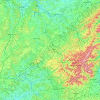
Nom : Carte topographique Vosges, altitude, relief.
Lieu : Vosges, Grand Est, France métropolitaine, France (47.81369 5.39361 48.51369 7.19837)
Altitude moyenne : 393 m
Altitude minimum : 191 m
Altitude maximum : 1 410 m
Itinéraires Grand Est, randonnée, VTT, course à pied et activités de plein air
Autres cartes topographiques
Cliquez sur une carte pour visualiser sa topographie, son altitude et son relief.
Château du Haut-Kœnigsbourg
France > Grand Est > Bas-Rhin > Orschwiller > Schaflager
Le château est situé dans le massif des Vosges à une altitude de 757 m à 12 km à l'ouest de Sélestat d'où il est visible. Il se trouve également à 26 km au nord de Colmar d'où il est également visible par temps clair et à 55 km au sud de Strasbourg.
Altitude moyenne : 442 m
Le Markstein
France > Grand Est > Haut-Rhin > Fellering
Le Markstein est une station de sports d'hiver, d'été et de détente (luge d'été et parapente) française, située dans le massif des Vosges, comprise entre 1 040 et 1 265 m d'altitude sur le passage de la route des Crêtes. Elle forme un ensemble de ski de fond avec le site du Breitfirst et la haute route…
Altitude moyenne : 1 013 m
Barrage du Lac de Pierre-Percée
France > Grand Est > Meurthe-et-Moselle > Pierre-Percée
Altitude moyenne : 398 m
Ballon d'Alsace
France > Grand Est > Haut-Rhin > Sewen
Le ballon d'Alsace, qui culmine à 1 247 mètres d'altitude, est l'un des premiers sommets significatifs lorsqu'on aborde le massif des Vosges par le sud. Il offre ainsi un large panorama, la Forêt-Noire à l'est, le Jura, la trouée de Belfort et, par temps clair, la chaîne des Alpes bernoises et le mont…
Altitude moyenne : 994 m
Mont Sainte-Odile
France > Grand Est > Bas-Rhin > Ottrott
Le mont Sainte-Odile (Odilieberri en alsacien, Odilienberg en allemand) est un mont vosgien, situé à Ottrott dans le département du Bas-Rhin, culminant à 767 mètres d'altitude.
Altitude moyenne : 599 m
Fort de Villey-le-Sec (Réduit)
France > Grand Est > Meurthe-et-Moselle > Villey-le-Sec
Altitude moyenne : 279 m
Grand Ballon
France > Grand Est > Haut-Rhin > Goldbach-Altenbach
La route des Crêtes contourne le sommet par l'est, franchissant un col à l'altitude de 1 341 mètres, entre le Markstein et le Hartmannswillerkopf (Vieil Armand).
Altitude moyenne : 1 139 m
Réserve biologique dirigée des Vallons de Gorze
France > Grand Est > Moselle > Gorze > Saint-Thiébaut
Altitude moyenne : 272 m
Réserve biologique dirigée de Faux de Verzy
France > Grand Est > Marne > Verzy
Altitude moyenne : 248 m
Lac du Forlet
France > Grand Est > Haut-Rhin > Soultzeren
Le lac des Truites, ou lac du Forlet, est le plus élevé des lacs vosgiens à 1 066 m d'altitude. Il est dénommé Forlenweier en alsacien et reïf tou blan en welsch.
Altitude moyenne : 1 134 m
Col du Grand Ballon
France > Grand Est > Haut-Rhin > Soultz-Haut-Rhin
La route des Crêtes contourne le sommet par l'est, franchissant un col à l'altitude de 1 341 mètres, entre le Markstein et le Hartmannswillerkopf (Vieil Armand).
Altitude moyenne : 1 143 m
Col de la Schlucht
France > Grand Est > Vosges > Le Valtin > La Schlucht
Situé à une altitude de 1 139 mètres, le col de la Schlucht fait communiquer les vallées lorraines de la Meurthe et de la Vologne avec la vallée alsacienne de la Fecht, un affluent de l'Ill. Les sources de la Meurthe et de la Fecht sont voisines du col de la Schlucht. La première coule sur les hauteurs…
Altitude moyenne : 1 068 m
Plateau de Malzéville
France > Grand Est > Dommartemont
D'une surface de 557 hectares (plateau et butte Sainte Geneviève), le plateau, majoritairement boisé de résineux, est classé site d'importance communautaire. Sa surface classée Natura 2000 représente 439 ha. Il culmine à 384 mètres d'altitude.
Altitude moyenne : 314 m
Vosges
France > Grand Est > Goldbach-Altenbach
Les Vosges sont un massif de moyennes montagnes du Nord-Est de la France qui sépare le plateau lorrain de la plaine d'Alsace. D'origine varisque et majoritairement constituées de grès et de granite, elles atteignent des altitudes modestes culminant à 1 424 mètres au Grand Ballon.
Altitude moyenne : 864 m