
Faire un don
Équipez-vous pour votre prochaine aventure :
En tant que Partenaire Amazon, ce site perçoit une commission sur les achats éligibles sans surcoût pour vous.
Carte topographique Devdaraki Glacier
Cliquez sur la carte pour afficher l’altitude.
Faire un don
Équipez-vous pour votre prochaine aventure :
En tant que Partenaire Amazon, ce site perçoit une commission sur les achats éligibles sans surcoût pour vous.
À propos de cette carte
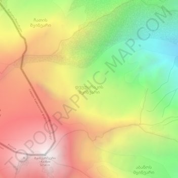
Nom : Carte topographique Devdaraki Glacier, altitude, relief.
Altitude moyenne : 3 789 m
Altitude minimum : 2 490 m
Altitude maximum : 5 032 m
Faire un don
Équipez-vous pour votre prochaine aventure :
En tant que Partenaire Amazon, ce site perçoit une commission sur les achats éligibles sans surcoût pour vous.
Autres cartes topographiques
Cliquez sur une carte pour visualiser sa topographie, son altitude et son relief.
Gudauri
Georgia > Mtskheta-Mtianeti > Kazbegi Municipality
Gudauri (Georgian: გუდაური) is a ski resort located on the south-facing plateau of The Greater Caucasus Mountain Range in Georgia. The resort is situated in the Kazbegi Municipality, along the Georgian Military Highway near the Jvari Pass, at an elevation of 2,200 meters (7,200 ft.) above sea…
Altitude moyenne : 2 161 m
Gudauri
Georgia > Mtskheta-Mtianeti > Kazbegi Municipality
Gudauri (Georgian: გუდაური) is a ski resort located on the south-facing plateau of The Greater Caucasus Mountain Range in Georgia. The resort is situated in the Stepantsminda District, along the Georgian Military Highway near the Jvari Pass, at an elevation of 2,200 meters (7,200 ft.) above sea…
Altitude moyenne : 2 161 m
Darial Gorge
Georgia > Mtskheta-Mtianeti > Kazbegi Municipality
The Russian fort, Darial, which guarded this section of the Georgian Military Road, was built at the northern end of the gorge, at an altitude of 1,447 metres (4,747 ft).
Altitude moyenne : 1 783 m
Faire un don
Équipez-vous pour votre prochaine aventure :
En tant que Partenaire Amazon, ce site perçoit une commission sur les achats éligibles sans surcoût pour vous.
Shan
Georgia > Mtskheta-Mtianeti > Kazbegi Municipality
Mt. Shani (Ingush: Шанлоам, lit. ''icy mountain''; Georgian: შანი; Russian: Шан) also known as Shan and Shanloam is a mountain in the Caucasus. It has an elevation of 4,451 metres (14,603 ft) and is on the international border between Georgia and Ingushetia, Russia.
Altitude moyenne : 3 620 m
Gudauri
Georgia > Mtskheta-Mtianeti > Kazbegi Municipality
Gudauri (Georgian: გუდაური) is a ski resort located on the south-facing plateau of The Greater Caucasus Mountain Range in Georgia. The resort is situated in the Kazbegi Municipality, along the Georgian Military Highway near the Jvari Pass, at an elevation of 2,200 meters (7,200 ft.) above sea…
Altitude moyenne : 2 161 m
Faire un don
Équipez-vous pour votre prochaine aventure :
En tant que Partenaire Amazon, ce site perçoit une commission sur les achats éligibles sans surcoût pour vous.
Faire un don
Équipez-vous pour votre prochaine aventure :
En tant que Partenaire Amazon, ce site perçoit une commission sur les achats éligibles sans surcoût pour vous.
Gudauri
Georgia > Mtskheta-Mtianeti > Kazbegi Municipality
Gudauri (Georgian: გუდაური) is a ski resort located on the south-facing plateau of The Greater Caucasus Mountain Range in Georgia. The resort is situated in the Stepantsminda District, along the Georgian Military Highway near the Jvari Pass, at an elevation of 2,200 meters (7,200 ft.) above sea…
Altitude moyenne : 2 161 m