
Faire un don
Équipez-vous pour votre prochaine aventure :
En tant que Partenaire Amazon, ce site perçoit une commission sur les achats éligibles sans surcoût pour vous.
Carte topographique Juta
Cliquez sur la carte pour afficher l’altitude.
Faire un don
Équipez-vous pour votre prochaine aventure :
En tant que Partenaire Amazon, ce site perçoit une commission sur les achats éligibles sans surcoût pour vous.
À propos de cette carte
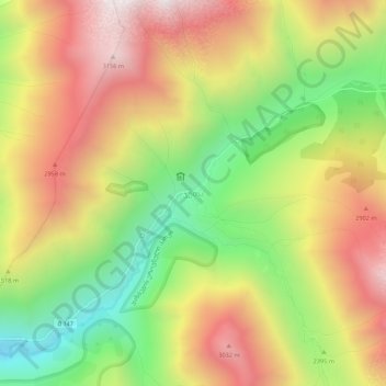
Nom : Carte topographique Juta, altitude, relief.
Lieu : Juta, Kazbegi Municipality, Mtskheta-Mtianeti, 4704, Georgia (42.55950 44.72476 42.59950 44.76476)
Altitude moyenne : 2 536 m
Altitude minimum : 1 872 m
Altitude maximum : 3 186 m
Faire un don
Équipez-vous pour votre prochaine aventure :
En tant que Partenaire Amazon, ce site perçoit une commission sur les achats éligibles sans surcoût pour vous.
Autres cartes topographiques
Cliquez sur une carte pour visualiser sa topographie, son altitude et son relief.
Gergeti Glacier
Georgia > Mtskheta-Mtianeti > Kazbegi Municipality
Gergeti (Georgian: გერგეთი; also known as Ortsveri) is a glacier located on the southeastern slope of Mt. Kazbek in the Kazbegi District of Georgia. The length of the Gergeti glacier is 7.1 km (4.4 mi) and its surface area is 11 km2 (4.2 sq mi). The tongue of Gergeti descends to 2,900 metres…
Altitude moyenne : 4 009 m
Stepantsminda
Georgia > Mtskheta-Mtianeti > Kazbegi Municipality
The town is located along the banks of the Terek River, 157 kilometers (98 mi) to the north of Tbilisi at an elevation of 1,740 meters (5,710 feet) above sea level. Stepantsminda’s climate is moderately humid with relatively dry, cold winters and long and cool summers. The average annual temperature is 4.9…
Altitude moyenne : 1 851 m
Faire un don
Équipez-vous pour votre prochaine aventure :
En tant que Partenaire Amazon, ce site perçoit une commission sur les achats éligibles sans surcoût pour vous.
Faire un don
Équipez-vous pour votre prochaine aventure :
En tant que Partenaire Amazon, ce site perçoit une commission sur les achats éligibles sans surcoût pour vous.
Stepantsminda
Georgia > Mtskheta-Mtianeti > Kazbegi Municipality
The town is located along the banks of the Terek River, 157 kilometers (98 mi) to the north of Tbilisi at an elevation of 1,740 meters (5,710 feet) above sea level. Stepantsminda’s climate is moderately humid with relatively dry, cold winters and long and cool summers. The average annual temperature is 4.9…
Altitude moyenne : 1 851 m