
Carte topographique Nieuwolda
Carte interactive
Cliquez sur la carte pour afficher l’altitude.
À propos de cette carte
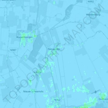
Nom : Carte topographique Nieuwolda, altitude, relief.
Lieu : Nieuwolda, Oldambt, Groningen, Nederland (53.21394 6.92864 53.26714 7.07974)
Altitude moyenne : -1 m
Altitude minimum : -7 m
Altitude maximum : 4 m
In Nieuwolda bevindt zich het museumgemaal De Hoogte dat door een historische Bronsmotor wordt aangedreven. Het kinderwagenmuseum is gevestigd in een monumentale boerderij uit ± 1750 (schuur) resp. 1905 (voorhuis). Ten noordwesten van Nieuwolda ligt sinds 1980 het Hondshalstermeer. Door het dorp loopt de Internationale Dollardroute voor fietsers. Langs Nieuwolda loopt de N362.
Autres cartes topographiques
Cliquez sur une carte pour visualiser sa topographie, son altitude et son relief.
Nieuw Beerta
Nederland > Groningen > Oldambt
Nieuw Beerta, Oldambt, Groningen, Nederland
Altitude moyenne : -2 m
Nieuw Scheemda
Nederland > Groningen > Oldambt
Nieuw Scheemda, Oldambt, Groningen, Nederland
Altitude moyenne : -1 m
Winschoterdiep
Nederland > Groningen > Oldambt
Winschoterdiep, Oldambt, Groningen, Nederland, 9636AL, Nederland
Altitude moyenne : 0 m