Géolocaliser

Carte topographique Ashwell

Cliquez sur la carte pour afficher l’altitude.

À propos de cette carte

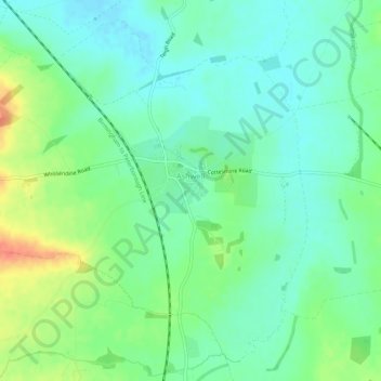
Nom : Carte topographique Ashwell, altitude, relief.

Lieu : Ashwell, Rutland, England, United Kingdom (52.69747 -0.75593 52.72708 -0.70172)

Altitude moyenne : 111 m

Altitude minimum : 94 m

Altitude maximum : 145 m

👉 Easily get elevation data in JSON, GeoTIFF and KML formats using Elevation API
Merci de soutenir ce site ❤️
Faire un don
🎯 Votre prochain emploi est peut-être à un message près : emploichat.fr

Autres cartes topographiques

Cliquez sur une carte pour visualiser sa topographie, son altitude et son relief.

Toll Bar

United Kingdom > England > Rutland

Altitude moyenne : 61 m

Cold Overton

United Kingdom > England > Rutland > Melton

Altitude moyenne : 171 m

Oakham Canal

United Kingdom > England > Rutland > Oakham

Altitude moyenne : 115 m

Tinwell

United Kingdom > England > Rutland

Altitude moyenne : 58 m

Merci de soutenir ce site ❤️
Faire un don
🎯 Votre prochain emploi est peut-être à un message près : emploichat.fr

Lyddington

United Kingdom > England > Rutland

Altitude moyenne : 93 m

Langham

United Kingdom > England > Rutland

Altitude moyenne : 135 m

Belton-in-Rutland

United Kingdom > England > Rutland

Altitude moyenne : 134 m

Belmesthorpe

United Kingdom > England > Rutland

Altitude moyenne : 39 m

Exton

United Kingdom > England > Rutland

Altitude moyenne : 113 m

Brooke

United Kingdom > England > Rutland

Altitude moyenne : 125 m

Seaton

United Kingdom > England > Rutland > Seaton

Altitude moyenne : 77 m

Horn Mill Spinney

United Kingdom > England > Rutland > Empingham

Altitude moyenne : 88 m

Caldecott

United Kingdom > England > Rutland > Caldecott

Altitude moyenne : 66 m

Ridlington

United Kingdom > England > Rutland > Ridlington

Altitude moyenne : 129 m

Merci de soutenir ce site ❤️
Faire un don
🎯 Votre prochain emploi est peut-être à un message près : emploichat.fr

Équipez-vous pour votre prochaine aventure :

🧺Serviette Microfibre - Séchage ultra-rapide et encombrement minimal
🦯Bâtons de randonnée - Bâtons télescopiques pour stabilité et réduction de l’effort
📍Balise de Détresse Satellite - Sécurité ultime pour les zones sans réseau mobile
🗺️Cartes topographiques - Cartes détaillées pour préparer itinéraires et randonnées
🗺️Cartes IGN - Cartes IGN officielles pour randonnée et orientation en France

En tant que Partenaire Amazon, ce site perçoit une commission sur les achats éligibles sans surcoût pour vous.