
Carte topographique Sabtang Island
Carte interactive
Cliquez sur la carte pour afficher l’altitude.
À propos de cette carte
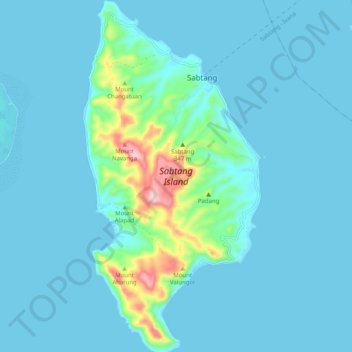
Nom : Carte topographique Sabtang Island, altitude, relief.
Altitude moyenne : 36 m
Altitude minimum : -1 m
Altitude maximum : 337 m
Autres cartes topographiques
Cliquez sur une carte pour visualiser sa topographie, son altitude et son relief.
Sabtang
Philippines > Batanes > Sabtang > Sabtang
Sabtang, Batanes, Cagayan Valley, 3904, Philippines
Altitude moyenne : 9 m