
Carte topographique Sabtang
Carte interactive
Cliquez sur la carte pour afficher l’altitude.
À propos de cette carte
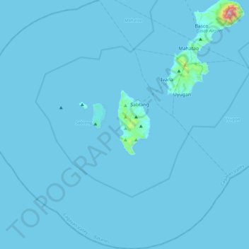
Nom : Carte topographique Sabtang, altitude, relief.
Lieu : Sabtang, Batanes, Cagayan Valley, 3904, Philippines (20.12389 121.63389 20.48646 122.01293)
Altitude moyenne : 9 m
Altitude minimum : 0 m
Altitude maximum : 1 001 m
Autres cartes topographiques
Cliquez sur une carte pour visualiser sa topographie, son altitude et son relief.
Sabtang Island
Philippines > Batanes > Sabtang
Sabtang Island, Sabtang, Batanes, Cagayan Valley, 3904, Philippines
Altitude moyenne : 36 m