
Carte topographique Anguganak
Carte interactive
Cliquez sur la carte pour afficher l’altitude.
À propos de cette carte
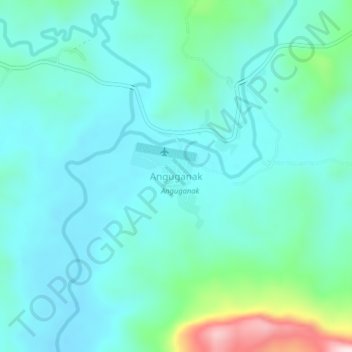
Nom : Carte topographique Anguganak, altitude, relief.
Lieu : Anguganak, Sandaun, Momase Region, Papua New Guinea (-3.58350 142.19885 -3.54350 142.23885)
Altitude moyenne : 331 m
Altitude minimum : 253 m
Altitude maximum : 683 m
Autres cartes topographiques
Cliquez sur une carte pour visualiser sa topographie, son altitude et son relief.
Vanimo District
Vanimo District, Sandaun, Momase Region, Papua New Guinea
Altitude moyenne : 185 m
Aitape District
Papua New Guinea > Sandaun > Aitape District
Aitape District, Sandaun, Momase Region, Papua New Guinea
Altitude moyenne : 150 m