
Carte topographique Great Skellig
Carte interactive
Cliquez sur la carte pour afficher l’altitude.
À propos de cette carte
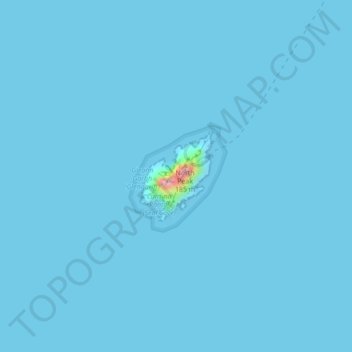
Nom : Carte topographique Great Skellig, altitude, relief.
Altitude moyenne : 1 m
Altitude minimum : 0 m
Altitude maximum : 161 m
Skellig Michael consists of approximately 22 hectares (54 acres) of rock, with its highest point, known as the Spit, 218 m (714 ft) above sea level. The island is defined by its twin peaks and intervening valley (known as Christ's Saddle), which make its landscape steep and inhospitable. It is best known for its Gaelic monastery, founded between the 6th and 8th centuries, and its variety of inhabiting species, which include gannets, puffins, a colony of razorbills and a population of approximately fifty grey seals. The island is of special interest to archaeologists, as the monastic settlement is in unusually good condition. The rock contains the remains of a tower house, a megalithic stone row and a cross-inscribed slab known as the Wailing Woman. The monastery is situated at an elevation of 170 to 180 m (550 to 600 ft), Christ's Saddle at 129 m (422 ft), and the flagstaff area at 37 m (120 ft) above sea level.
Autres cartes topographiques
Cliquez sur une carte pour visualiser sa topographie, son altitude et son relief.
Killarney
Killarney, Killarney Municipal District, County Kerry, Munster, Ireland
Altitude moyenne : 57 m
Brick
Brick, Lixnaw ED, Listowel Municipal District, County Kerry, Munster, Ireland
Altitude moyenne : 5 m
Caher
Caher, Kenmare Municipal District, County Kerry, Munster, V93 A8N1, Ireland
Altitude moyenne : 617 m
Kenmare Municipal District
Kenmare Municipal District, County Kerry, Munster, Ireland
Altitude moyenne : 98 m
Tralee
Ireland > County Kerry > Tralee
Tralee, Tralee Municipal District, County Kerry, Munster, Ireland
Altitude moyenne : 20 m
Dingle
Dingle, Kenmare Municipal District, County Kerry, Munster, Ireland
Altitude moyenne : 121 m
Brick
Brick, Lixnaw ED, Listowel Municipal District, County Kerry, Munster, Ireland
Altitude moyenne : 5 m
Carrauntoohil
Carrauntoohil, Kenmare Municipal District, County Kerry, Munster, V93 A8N1, Ireland
Altitude moyenne : 644 m