
Carte topographique Caher
Carte interactive
Cliquez sur la carte pour afficher l’altitude.
À propos de cette carte
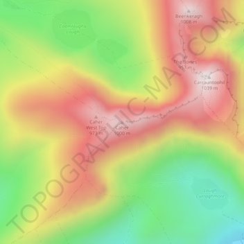
Nom : Carte topographique Caher, altitude, relief.
Altitude moyenne : 617 m
Altitude minimum : 189 m
Altitude maximum : 1 017 m
Autres cartes topographiques
Cliquez sur une carte pour visualiser sa topographie, son altitude et son relief.
Great Skellig
Great Skellig, Kenmare Municipal District, County Kerry, Munster, Ireland
Altitude moyenne : 1 m
Killarney
Killarney, Killarney Municipal District, County Kerry, Munster, Ireland
Altitude moyenne : 57 m
Brick
Brick, Lixnaw ED, Listowel Municipal District, County Kerry, Munster, Ireland
Altitude moyenne : 5 m
Kenmare Municipal District
Kenmare Municipal District, County Kerry, Munster, Ireland
Altitude moyenne : 98 m
Tralee
Ireland > County Kerry > Tralee
Tralee, Tralee Municipal District, County Kerry, Munster, Ireland
Altitude moyenne : 20 m
Dingle
Dingle, Kenmare Municipal District, County Kerry, Munster, Ireland
Altitude moyenne : 121 m
Brick
Brick, Lixnaw ED, Listowel Municipal District, County Kerry, Munster, Ireland
Altitude moyenne : 5 m
Carrauntoohil
Carrauntoohil, Kenmare Municipal District, County Kerry, Munster, V93 A8N1, Ireland
Altitude moyenne : 644 m