
Carte topographique Centralia
Carte interactive
Cliquez sur la carte pour afficher l’altitude.
À propos de cette carte
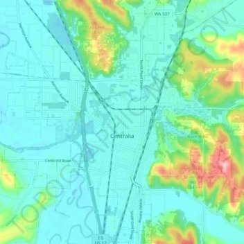
Nom : Carte topographique Centralia, altitude, relief.
Lieu : Centralia, Lewis County, Washington, United States (46.69155 -123.01989 46.75665 -122.92395)
Altitude moyenne : 74 m
Altitude minimum : 43 m
Altitude maximum : 195 m
Autres cartes topographiques
Cliquez sur une carte pour visualiser sa topographie, son altitude et son relief.
Cinebar
United States > Washington > Lewis County
Cinebar, Lewis County, Washington, 98533, United States
Altitude moyenne : 308 m
Narada Falls
United States > Washington > Lewis County
Narada Falls, Lewis County, Washington, United States
Altitude moyenne : 1 444 m
Fords Prairie
United States > Washington > Lewis County
Fords Prairie, Lewis County, Washington, United States
Altitude moyenne : 67 m
Bremer
United States > Washington > Lewis County
Bremer, Lewis County, Washington, United States
Altitude moyenne : 430 m
Walupt Creek Falls
United States > Washington > Lewis County
Walupt Creek Falls, Lewis County, Washington, United States
Altitude moyenne : 1 158 m
Napavine
United States > Washington > Lewis County
Napavine, Lewis County, Washington, 98565, United States
Altitude moyenne : 105 m
Chehalis
United States > Washington > Lewis County
Chehalis, Lewis County, Washington, United States
Altitude moyenne : 81 m
Adna
United States > Washington > Lewis County
Adna, Lewis County, Washington, United States
Altitude moyenne : 82 m
Chimney Rock
United States > Washington > Lewis County
Chimney Rock, Lewis County, Washington, United States
Altitude moyenne : 1 593 m
Glenoma
United States > Washington > Lewis County
Glenoma, Lewis County, Washington, 98336, United States
Altitude moyenne : 354 m
Vader
United States > Washington > Lewis County
Vader, Lewis County, Washington, 98593, United States
Altitude moyenne : 74 m
Morton
United States > Washington > Lewis County
Morton, Lewis County, Washington, United States
Altitude moyenne : 328 m
Winlock
United States > Washington > Lewis County
Winlock, Lewis County, Washington, United States
Altitude moyenne : 124 m
Onalaska
United States > Washington > Lewis County
Onalaska, Lewis County, Washington, 98570, United States
Altitude moyenne : 170 m
Mossyrock
United States > Washington > Lewis County > Mossyrock
Mossyrock, Lewis County, Washington, 98564, United States
Altitude moyenne : 213 m
Mineral
United States > Washington > Lewis County > Mineral
Mineral, Lewis County, Washington, 98355, United States
Altitude moyenne : 481 m
Randle
United States > Washington > Lewis County
Randle, Lewis County, Washington, United States
Altitude moyenne : 378 m
Packwood
United States > Washington > Lewis County
Packwood, Lewis County, Washington, United States
Altitude moyenne : 379 m