
Carte topographique Winlock
Carte interactive
Cliquez sur la carte pour afficher l’altitude.
À propos de cette carte
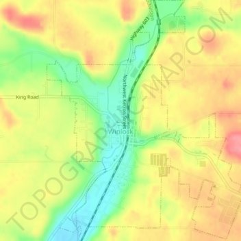
Nom : Carte topographique Winlock, altitude, relief.
Lieu : Winlock, Lewis County, Washington, United States (46.48013 -122.95086 46.50712 -122.91892)
Altitude moyenne : 124 m
Altitude minimum : 78 m
Altitude maximum : 162 m
The eastern edge of the Willapa Hills lie to the west. To the east are relatively flat prairies. A notable landmark about four miles west of town is Sam Henry Mountain, elevation 1,492 feet (455 m), named for an early section superintendent of the Northern Pacific Railroad. Mt. St. Helens, about forty miles (64.4 km) to the east can be seen from viewpoints around the area. In May 1980, Winlock was covered with about one inch (2.54 cm) of volcanic ash from the second major eruption of this peak one week after the cataclysmic eruption of May 18.
Autres cartes topographiques
Cliquez sur une carte pour visualiser sa topographie, son altitude et son relief.
Cinebar
United States > Washington > Lewis County
Cinebar, Lewis County, Washington, 98533, United States
Altitude moyenne : 308 m
Narada Falls
United States > Washington > Lewis County
Narada Falls, Lewis County, Washington, United States
Altitude moyenne : 1 444 m
Fords Prairie
United States > Washington > Lewis County
Fords Prairie, Lewis County, Washington, United States
Altitude moyenne : 67 m
Bremer
United States > Washington > Lewis County
Bremer, Lewis County, Washington, United States
Altitude moyenne : 430 m
Walupt Creek Falls
United States > Washington > Lewis County
Walupt Creek Falls, Lewis County, Washington, United States
Altitude moyenne : 1 158 m
Centralia
United States > Washington > Lewis County
Centralia, Lewis County, Washington, United States
Altitude moyenne : 74 m
Napavine
United States > Washington > Lewis County
Napavine, Lewis County, Washington, 98565, United States
Altitude moyenne : 105 m
Chehalis
United States > Washington > Lewis County
Chehalis, Lewis County, Washington, United States
Altitude moyenne : 81 m
Adna
United States > Washington > Lewis County
Adna, Lewis County, Washington, United States
Altitude moyenne : 82 m
Chimney Rock
United States > Washington > Lewis County
Chimney Rock, Lewis County, Washington, United States
Altitude moyenne : 1 593 m
Glenoma
United States > Washington > Lewis County
Glenoma, Lewis County, Washington, 98336, United States
Altitude moyenne : 354 m
Vader
United States > Washington > Lewis County
Vader, Lewis County, Washington, 98593, United States
Altitude moyenne : 74 m
Morton
United States > Washington > Lewis County
Morton, Lewis County, Washington, United States
Altitude moyenne : 328 m
Onalaska
United States > Washington > Lewis County
Onalaska, Lewis County, Washington, 98570, United States
Altitude moyenne : 170 m
Mossyrock
United States > Washington > Lewis County > Mossyrock
Mossyrock, Lewis County, Washington, 98564, United States
Altitude moyenne : 213 m
Mineral
United States > Washington > Lewis County > Mineral
Mineral, Lewis County, Washington, 98355, United States
Altitude moyenne : 481 m
Randle
United States > Washington > Lewis County
Randle, Lewis County, Washington, United States
Altitude moyenne : 378 m
Packwood
United States > Washington > Lewis County
Packwood, Lewis County, Washington, United States
Altitude moyenne : 379 m