
Carte topographique Mszalnica
Carte interactive
Cliquez sur la carte pour afficher l’altitude.
À propos de cette carte
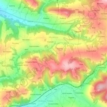
Nom : Carte topographique Mszalnica, altitude, relief.
Altitude moyenne : 474 m
Altitude minimum : 362 m
Altitude maximum : 578 m
Autres cartes topographiques
Cliquez sur une carte pour visualiser sa topographie, son altitude et son relief.
Ptaszkowa
Poland > Lesser Poland Voivodeship > Nowy Sącz County
Ptaszkowa, gmina Grybów, Nowy Sącz County, Lesser Poland Voivodeship, 33-333, Poland
Altitude moyenne : 534 m
Zabrzeż
Poland > Lesser Poland Voivodeship > Nowy Sącz County
Zabrzeż, gmina Łącko, Nowy Sącz County, Lesser Poland Voivodeship, Poland
Altitude moyenne : 479 m
Święty Krzyż
Poland > Lesser Poland Voivodeship > Nowy Sącz County > Królowa Polska > Góry
Święty Krzyż, Granica, Góry, Królowa Polska, gmina Kamionka Wielka, Nowy Sącz County, Lesser Poland Voivodeship, 33-334, Poland
Altitude moyenne : 463 m
Grybów
Poland > Lesser Poland Voivodeship > Nowy Sącz County > Grybów
Grybów, Nowy Sącz County, Lesser Poland Voivodeship, Poland
Altitude moyenne : 433 m