
Carte topographique Moulovi Para
Carte interactive
Cliquez sur la carte pour afficher l’altitude.
À propos de cette carte
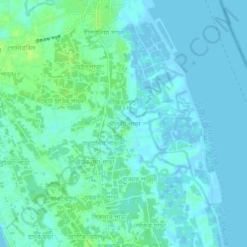
Nom : Carte topographique Moulovi Para, altitude, relief.
Altitude moyenne : 4 m
Altitude minimum : -5 m
Altitude maximum : 12 m
Autres cartes topographiques
Cliquez sur une carte pour visualiser sa topographie, son altitude et son relief.
Chattogram
Bangladesh > Chattogram Division
Chattogram, Chattogram District, Chattogram Division, 4000, Bangladesh
Altitude moyenne : 6 m
Cox's Bazar
Bangladesh > Chattogram Division > Cox's Bazar
Cox's Bazar, Cox's Bazar District, Chattogram Division, 4700, Bangladesh
Altitude moyenne : 13 m
অক্সিজেন
Bangladesh > Chattogram Division > অক্সিজেন
অক্সিজেন, Chattogram District, Chattogram Division, 4223, Bangladesh
Altitude moyenne : 15 m
Khuruskul
Bangladesh > Chattogram Division > Khuruskul
Khuruskul, Cox's Bazar District, Chattogram Division, ৪৭০০, Bangladesh
Altitude moyenne : 5 m
Kaptai Lake
Bangladesh > Chattogram Division
Kaptai Lake, Rangamati Hill District, Chattogram Division, Bangladesh
Altitude moyenne : 102 m