
Carte topographique Rathmichael (Bray) ED
Carte interactive
Cliquez sur la carte pour afficher l’altitude.
À propos de cette carte
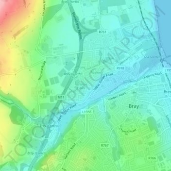
Nom : Carte topographique Rathmichael (Bray) ED, altitude, relief.
Altitude moyenne : 36 m
Altitude minimum : 0 m
Altitude maximum : 136 m
Autres cartes topographiques
Cliquez sur une carte pour visualiser sa topographie, son altitude et son relief.
Roundwood
Roundwood, The Municipal District of Wicklow, County Wicklow, Leinster, Ireland
Altitude moyenne : 242 m
Aughrim
Aughrim, The Municipal District of Arklow, County Wicklow, Leinster, Y14 HT72, Ireland
Altitude moyenne : 123 m
Toberbeg
Toberbeg, Dunlavin ED, The Municipal District of Baltinglass, County Wicklow, Leinster, Ireland
Altitude moyenne : 207 m