Géolocaliser

Carte topographique Fleckney

Cliquez sur la carte pour afficher l’altitude.

À propos de cette carte

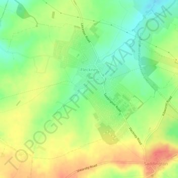
Nom : Carte topographique Fleckney, altitude, relief.

Lieu : Fleckney, Harborough, Leicestershire, England, United Kingdom (52.52250 -1.07590 52.54400 -1.03085)

Altitude moyenne : 121 m

Altitude minimum : 94 m

Altitude maximum : 149 m

Autres cartes topographiques

Cliquez sur une carte pour visualiser sa topographie, son altitude et son relief.

Tugby

United Kingdom > England > Leicestershire > Harborough

Altitude moyenne : 158 m

Shangton

United Kingdom > England > Leicestershire > Harborough

Altitude moyenne : 127 m

Saddington

United Kingdom > England > Leicestershire > Harborough

Altitude moyenne : 126 m

Tur Langton

United Kingdom > England > Leicestershire > Harborough

Altitude moyenne : 113 m

Goadby

United Kingdom > England > Leicestershire > Harborough

Altitude moyenne : 148 m

Burton Overy

United Kingdom > England > Leicestershire > Harborough

Altitude moyenne : 130 m

Rolleston

United Kingdom > England > Leicestershire > Harborough

Altitude moyenne : 166 m

Gilmorton

United Kingdom > England > Leicestershire > Harborough

Altitude moyenne : 136 m

Drayton

United Kingdom > England > Leicestershire > Harborough

Altitude moyenne : 82 m

Scraptoft

United Kingdom > England > Leicestershire > Harborough

Altitude moyenne : 103 m

Ashby Parva

United Kingdom > England > Leicestershire > Harborough

Altitude moyenne : 126 m

Foxton

United Kingdom > England > Leicestershire > Harborough

Altitude moyenne : 107 m

Bitteswell

United Kingdom > England > Leicestershire > Harborough

Altitude moyenne : 128 m

Mowsley

United Kingdom > England > Leicestershire > Harborough

Altitude moyenne : 147 m

Thurnby

United Kingdom > England > Leicestershire > Harborough

Altitude moyenne : 109 m

Shawell

United Kingdom > England > Leicestershire > Harborough > Shawell

Altitude moyenne : 125 m

Hungarton

United Kingdom > England > Leicestershire > Harborough > Hungarton

Altitude moyenne : 130 m

Foxton Locks

United Kingdom > England > Leicestershire > Harborough > Gumley

Altitude moyenne : 120 m

Bringhurst

United Kingdom > England > Leicestershire > Harborough

Altitude moyenne : 74 m

Glooston

United Kingdom > England > Leicestershire > Harborough > Glooston

Altitude moyenne : 117 m

Horninghold

United Kingdom > England > Leicestershire > Harborough

Altitude moyenne : 124 m

Bushby

United Kingdom > England > Leicestershire > Harborough

Altitude moyenne : 113 m

Équipez-vous pour votre prochaine aventure :

🪢Corde Paracorde - Corde de survie ultra-résistante pour usages multiples
🕶️Lunettes Glacier Catégorie 4 - Protection maximale contre la réverbération en haute montagne
🕶️Lunettes de soleil randonnée - Protection UV pour la montagne et la marche
📱Supports smartphone randonnée - Fixations pratiques pour navigation mobile
🧼Savon Biodégradable - Hygiène respectueuse de l'environnement en bivouac

En tant que Partenaire Amazon, ce site perçoit une commission sur les achats éligibles sans surcoût pour vous.