
Carte topographique Bringhurst
Cliquez sur la carte pour afficher l’altitude.
À propos de cette carte
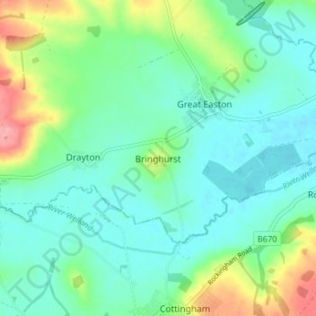
Nom : Carte topographique Bringhurst, altitude, relief.
Altitude moyenne : 74 m
Altitude minimum : 49 m
Altitude maximum : 145 m
Autres cartes topographiques
Cliquez sur une carte pour visualiser sa topographie, son altitude et son relief.
Great Glen
United Kingdom > England > Leicestershire > Harborough > Great Glen
Altitude moyenne : 115 m
Adrian's Spinney
United Kingdom > England > Leicestershire > Harborough > Stoughton
Altitude moyenne : 113 m
South Kilworth
United Kingdom > England > Leicestershire > Harborough > South Kilworth
Altitude moyenne : 134 m
Broughton Astley
United Kingdom > England > Leicestershire > Harborough > Broughton Astley
Altitude moyenne : 87 m
Kimcote and Walton
United Kingdom > England > Leicestershire > Harborough > Kimcote and Walton
Altitude moyenne : 144 m
Saddington
United Kingdom > England > Leicestershire > Harborough > Saddington
Altitude moyenne : 127 m
Little Stretton
United Kingdom > England > Leicestershire > Harborough > Little Stretton
Altitude moyenne : 132 m
Claybrooke Magna
United Kingdom > England > Leicestershire > Harborough > Claybrooke Magna
Altitude moyenne : 102 m
Stonton Wyville
United Kingdom > England > Leicestershire > Harborough > Stonton Wyville
Altitude moyenne : 113 m
Burton Overy
United Kingdom > England > Leicestershire > Harborough > Burton Overy
Altitude moyenne : 126 m
Saddington Reservoir
United Kingdom > England > Leicestershire > Harborough > Saddington
Altitude moyenne : 128 m
Smeeton Westerby
United Kingdom > England > Leicestershire > Harborough > Smeeton Westerby
Altitude moyenne : 112 m
Bruntingthorpe
United Kingdom > England > Leicestershire > Harborough > Bruntingthorpe
Altitude moyenne : 132 m
Dunton Bassett
United Kingdom > England > Leicestershire > Harborough > Dunton Bassett
Altitude moyenne : 115 m
Husbands Bosworth
United Kingdom > England > Leicestershire > Harborough > Husbands Bosworth
Altitude moyenne : 142 m