
Carte topographique Loh
Carte interactive
Cliquez sur la carte pour afficher l’altitude.
À propos de cette carte
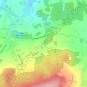
Nom : Carte topographique Loh, altitude, relief.
Lieu : Loh, Kirchberg, Zwickau, Saxony, 08147, Germany (50.55431 12.49233 50.57743 12.49970)
Altitude moyenne : 517 m
Altitude minimum : 436 m
Altitude maximum : 631 m
Autres cartes topographiques
Cliquez sur une carte pour visualiser sa topographie, son altitude et son relief.
Löbau
Germany > Saxony > Görlitz - Zhorjelc
Löbau, Görlitz - Zhorjelc, Saxony, 02708, Germany
Altitude moyenne : 273 m
Marienberg
Germany > Saxony > Erzgebirgskreis
Marienberg, Erzgebirgskreis, Saxony, 09496, Germany
Altitude moyenne : 657 m
Bautzen - Budyšin
Bautzen - Budyšin, Bautzen, Saxony, 02625, Germany
Altitude moyenne : 210 m
Grimma
Germany > Saxony > Landkreis Leipzig > Grimma
Grimma, Landkreis Leipzig, Saxony, 04668, Germany
Altitude moyenne : 162 m
Schkeuditz
Germany > Saxony > Schkeuditz
Schkeuditz, Nordsachsen, Saxony, 04435, Germany
Altitude moyenne : 116 m
Northern Eagle Owl
Northern Eagle Owl, Zittau, Görlitz, Saxony, 02797, Germany
Altitude moyenne : 440 m
Centre North West
Centre North West, Mitte, Leipzig, Saxony, 04105, Germany
Altitude moyenne : 111 m
Fichtelberg
Germany > Saxony > Oberwiesenthal
Fichtelberg, Oberwiesenthal, Erzgebirgskreis, Saxony, 09484, Germany
Altitude moyenne : 1 038 m