
Carte topographique South Cotabato
Carte interactive
Cliquez sur la carte pour afficher l’altitude.
À propos de cette carte
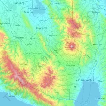
Nom : Carte topographique South Cotabato, altitude, relief.
Lieu : South Cotabato, Soccsksargen, Philippines (5.92838 124.24390 6.66302 125.27588)
Altitude moyenne : 352 m
Altitude minimum : -4 m
Altitude maximum : 2 240 m
Maximum daytime temperature throughout the province is in the range of 36 to 38 °C (97 to 100 °F), falling to 23 to 32 °C (73 to 90 °F) during the night depending on the elevation. The hottest period is January to April while July to December being the coolest.
Autres cartes topographiques
Cliquez sur une carte pour visualiser sa topographie, son altitude et son relief.
General Santos
Philippines > South Cotabato > General Santos
General Santos, South Cotabato, Soccsksargen, 9500, Philippines
Altitude moyenne : 149 m
Glamang
Philippines > South Cotabato > Polomolok
Glamang, Polomolok, South Cotabato, Soccsksargen, 9504, Philippines
Altitude moyenne : 223 m
Lake Holon
Philippines > South Cotabato > T'Boli
Lake Holon, T'Boli, South Cotabato, Philippines
Altitude moyenne : 1 452 m
Lake Sebu
Lake Sebu, South Cotabato, Soccsksargen, 9514, Philippines
Altitude moyenne : 750 m
Tinagacan
Philippines > South Cotabato > General Santos > Tinagacan
Tinagacan, General Santos, South Cotabato, Soccsksargen, Philippines
Altitude moyenne : 58 m
Batomelong
Philippines > South Cotabato > General Santos > Batomelong
Batomelong, General Santos, South Cotabato, Soccsksargen, Philippines
Altitude moyenne : 86 m