
Carte topographique Lake Sebu
Carte interactive
Cliquez sur la carte pour afficher l’altitude.
À propos de cette carte
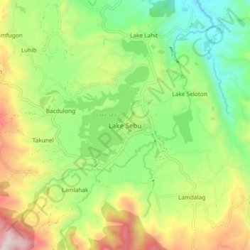
Nom : Carte topographique Lake Sebu, altitude, relief.
Lieu : Lake Sebu, South Cotabato, Soccsksargen, 9514, Philippines (6.18600 124.67157 6.26600 124.75157)
Altitude moyenne : 750 m
Altitude minimum : 344 m
Altitude maximum : 1 389 m
The placid lake of Lake Sebu can be found in Allah Valley near the municipality of Surallah, South Cotabato. Surrounded by rolling hills and mountains covered with thick rain forest, the lake has an area of 354 hectares (870 acres), with an elevation of approximately 1,000 metres (3,300 ft).
Autres cartes topographiques
Cliquez sur une carte pour visualiser sa topographie, son altitude et son relief.
General Santos
Philippines > South Cotabato > General Santos
General Santos, South Cotabato, Soccsksargen, 9500, Philippines
Altitude moyenne : 149 m
Glamang
Philippines > South Cotabato > Polomolok
Glamang, Polomolok, South Cotabato, Soccsksargen, 9504, Philippines
Altitude moyenne : 223 m
Lake Holon
Philippines > South Cotabato > T'Boli
Lake Holon, T'Boli, South Cotabato, Philippines
Altitude moyenne : 1 452 m
South Cotabato
South Cotabato, Soccsksargen, Philippines
Altitude moyenne : 352 m
Tinagacan
Philippines > South Cotabato > General Santos > Tinagacan
Tinagacan, General Santos, South Cotabato, Soccsksargen, Philippines
Altitude moyenne : 58 m
Batomelong
Philippines > South Cotabato > General Santos > Batomelong
Batomelong, General Santos, South Cotabato, Soccsksargen, Philippines
Altitude moyenne : 86 m