
Faire un don
Équipez-vous pour votre prochaine aventure :
En tant que Partenaire Amazon, ce site perçoit une commission sur les achats éligibles sans surcoût pour vous.
Carte topographique Worms-Nord
Cliquez sur la carte pour afficher l’altitude.
Faire un don
Équipez-vous pour votre prochaine aventure :
En tant que Partenaire Amazon, ce site perçoit une commission sur les achats éligibles sans surcoût pour vous.
À propos de cette carte
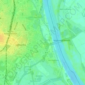
Nom : Carte topographique Worms-Nord, altitude, relief.
Altitude moyenne : 94 m
Altitude minimum : 83 m
Altitude maximum : 110 m
Faire un don
Équipez-vous pour votre prochaine aventure :
En tant que Partenaire Amazon, ce site perçoit une commission sur les achats éligibles sans surcoût pour vous.
Autres cartes topographiques
Cliquez sur une carte pour visualiser sa topographie, son altitude et son relief.
Worms
Deutschland > Rheinland-Pfalz > Worms
Das langjährige Mittel der Lufttemperatur des Zeitraums 1951 bis 1980 beträgt 10,3 °C. In den vergangenen Jahren wurde eine Steigerung des Jahresmittels der Lufttemperatur beobachtet. So betrug im Jahr 2008 die gemittelte Lufttemperatur an der Hagenstraße 12,2 °C, während im gleichen Zeitraum fünf…
Altitude moyenne : 100 m
Leiselheim
Deutschland > Rheinland-Pfalz > Worms
Leiselheim liegt am Nordrand des Pfrimmtals, am Übergang von der Talaue zum fruchtbaren Lössriedel. Das west-ost-gerichtete Straßendorf wurde seit Ende des 19. Jahrhunderts durch mehrere Baugebiete sowohl in die überschwemmungsgefährdete Pfrimmaue wie auch auf den Rand des Riedels erweitert. Im Osten…
Altitude moyenne : 125 m
Ibersheim
Deutschland > Rheinland-Pfalz > Worms
1621 eroberten die spanischen Truppen der kaiserlich-katholischen Liga unter ihrem Kommandeur Gonzalo Fernández de Córdoba die Burg Stein und errichteten ihr Lager zwischen Ibersheim und Rheindürkheim. 1631 beim Herannahen der Schweden unter Gustav II. Adolf wurde die Burg und die Pontonbrücke von den…
Altitude moyenne : 89 m
Faire un don
Équipez-vous pour votre prochaine aventure :
En tant que Partenaire Amazon, ce site perçoit une commission sur les achats éligibles sans surcoût pour vous.