
Faire un don
Équipez-vous pour votre prochaine aventure :
En tant que Partenaire Amazon, ce site perçoit une commission sur les achats éligibles sans surcoût pour vous.
Carte topographique Weinsheim
Cliquez sur la carte pour afficher l’altitude.
Faire un don
Équipez-vous pour votre prochaine aventure :
En tant que Partenaire Amazon, ce site perçoit une commission sur les achats éligibles sans surcoût pour vous.
À propos de cette carte
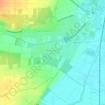
Nom : Carte topographique Weinsheim, altitude, relief.
Lieu : Weinsheim, Vororte Südwest, Worms, Rheinland-Pfalz, Deutschland (49.59323 8.30676 49.61591 8.35302)
Altitude moyenne : 103 m
Altitude minimum : 90 m
Altitude maximum : 127 m
Faire un don
Équipez-vous pour votre prochaine aventure :
En tant que Partenaire Amazon, ce site perçoit une commission sur les achats éligibles sans surcoût pour vous.
Autres cartes topographiques
Cliquez sur une carte pour visualiser sa topographie, son altitude et son relief.
Worms
Deutschland > Rheinland-Pfalz > Worms
Das langjährige Mittel der Lufttemperatur des Zeitraums 1951 bis 1980 beträgt 10,3 °C. In den vergangenen Jahren wurde eine Steigerung des Jahresmittels der Lufttemperatur beobachtet. So betrug im Jahr 2008 die gemittelte Lufttemperatur an der Hagenstraße 12,2 °C, während im gleichen Zeitraum fünf…
Altitude moyenne : 100 m