
Carte topographique Council Bluffs
Carte interactive
Cliquez sur la carte pour afficher l’altitude.
À propos de cette carte
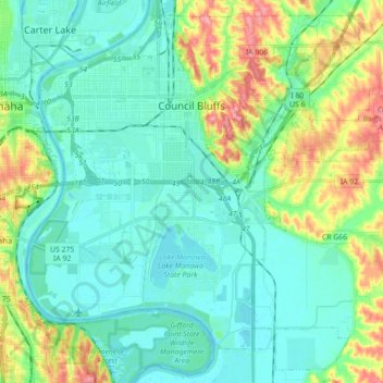
Nom : Carte topographique Council Bluffs, altitude, relief.
Lieu : Council Bluffs, Pottawattamie County, Iowa, United States (41.16725 -95.92725 41.29073 -95.75109)
Altitude moyenne : 315 m
Altitude minimum : 291 m
Altitude maximum : 386 m
Autres cartes topographiques
Cliquez sur une carte pour visualiser sa topographie, son altitude et son relief.
Loveland
United States > Iowa > Pottawattamie County
Loveland, Pottawattamie County, Iowa, United States
Altitude moyenne : 330 m
Council Bluffs
United States > Iowa > Pottawattamie County > Council Bluffs
Council Bluffs, Pottawattamie County, Iowa, 51502, United States
Altitude moyenne : 338 m