
Carte topographique Loveland
Carte interactive
Cliquez sur la carte pour afficher l’altitude.
À propos de cette carte
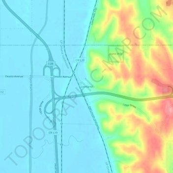
Nom : Carte topographique Loveland, altitude, relief.
Lieu : Loveland, Pottawattamie County, Iowa, United States (41.47699 -95.91082 41.51699 -95.87082)
Altitude moyenne : 330 m
Altitude minimum : 300 m
Altitude maximum : 413 m
Autres cartes topographiques
Cliquez sur une carte pour visualiser sa topographie, son altitude et son relief.
Council Bluffs
United States > Iowa > Pottawattamie County > Council Bluffs
Council Bluffs, Pottawattamie County, Iowa, 51502, United States
Altitude moyenne : 338 m
Council Bluffs
United States > Iowa > Pottawattamie County
Council Bluffs, Pottawattamie County, Iowa, United States
Altitude moyenne : 315 m