
Carte topographique Na Mom
Carte interactive
Cliquez sur la carte pour afficher l’altitude.
À propos de cette carte
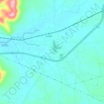
Nom : Carte topographique Na Mom, altitude, relief.
Lieu : Na Mom, Ban Rai, Songkhla Province, 90310, Thailand (6.93846 100.53643 6.97846 100.57643)
Altitude moyenne : 43 m
Altitude minimum : 15 m
Altitude maximum : 210 m
Autres cartes topographiques
Cliquez sur une carte pour visualiser sa topographie, son altitude et son relief.
Upper Level. Highest accessible level. You won't see Amy other visitors. Good place to take a swim.
Upper Level. Highest accessible level. You won't see Amy other visitors. Good place to take a swim., Songkhla Province, Thailand
Altitude moyenne : 397 m
Tha Phraya
Tha Phraya, Songkhla Province, Thailand
Altitude moyenne : 93 m
Hat Yai
Hat Yai, Kho Hong, Songkhla Province, Thailand
Altitude moyenne : 47 m
Ban Phru
Ban Phru, Ban Rai, Songkhla Province, 90230, Thailand
Altitude moyenne : 31 m