
Carte topographique County Waterford
Carte interactive
Cliquez sur la carte pour afficher l’altitude.
À propos de cette carte
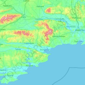
Nom : Carte topographique County Waterford, altitude, relief.
Lieu : County Waterford, Munster, Ireland (51.93792 -8.16278 52.36390 -6.94994)
Altitude moyenne : 86 m
Altitude minimum : -2 m
Altitude maximum : 898 m
Autres cartes topographiques
Cliquez sur une carte pour visualiser sa topographie, son altitude et son relief.
Lismore
Lismore, The Municipal District of Dungarvan — Lismore, County Waterford, Munster, P51 VW44, Ireland
Altitude moyenne : 38 m
Mahon Falls
Mahon Falls, Mahon Falls Walk, Comeragh, The Municipal District of Comeragh, County Waterford, Munster, Ireland
Altitude moyenne : 575 m
St. Stephen's Within
Ireland > County Waterford > Waterford
St. Stephen's Within, Centre B, Waterford, County Waterford, Munster, Ireland
Altitude moyenne : 26 m
Crotty's Rock
Crotty's Rock, Ross, The Municipal District of Comeragh, County Waterford, Munster, Ireland
Altitude moyenne : 424 m
Millstreet
Millstreet, Ballynamult, The Municipal District of Dungarvan — Lismore, County Waterford, Munster, Ireland
Altitude moyenne : 112 m
Park
Ireland > County Waterford > Waterford
Park, Waterford, County Waterford, Munster, Ireland
Altitude moyenne : 22 m
Portlaw
Portlaw, The Municipal District of Comeragh, County Waterford, Munster, Ireland
Altitude moyenne : 76 m
Waterford City Metropolitan District
Waterford City Metropolitan District, County Waterford, Munster, Ireland
Altitude moyenne : 29 m
Dungarvan
Dungarvan, The Municipal District of Dungarvan — Lismore, County Waterford, Munster, X35 V670, Ireland
Altitude moyenne : 30 m
Waterford
Waterford, County Waterford, Munster, Ireland
Altitude moyenne : 33 m