
Carte topographique Lismore
Carte interactive
Cliquez sur la carte pour afficher l’altitude.
À propos de cette carte
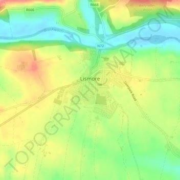
Nom : Carte topographique Lismore, altitude, relief.
Altitude moyenne : 38 m
Altitude minimum : 2 m
Altitude maximum : 79 m
Autres cartes topographiques
Cliquez sur une carte pour visualiser sa topographie, son altitude et son relief.
Mahon Falls
Mahon Falls, Mahon Falls Walk, Comeragh, The Municipal District of Comeragh, County Waterford, Munster, Ireland
Altitude moyenne : 575 m
St. Stephen's Within
Ireland > County Waterford > Waterford
St. Stephen's Within, Centre B, Waterford, County Waterford, Munster, Ireland
Altitude moyenne : 26 m
Crotty's Rock
Crotty's Rock, Ross, The Municipal District of Comeragh, County Waterford, Munster, Ireland
Altitude moyenne : 424 m
Millstreet
Millstreet, Ballynamult, The Municipal District of Dungarvan — Lismore, County Waterford, Munster, Ireland
Altitude moyenne : 112 m
Park
Ireland > County Waterford > Waterford
Park, Waterford, County Waterford, Munster, Ireland
Altitude moyenne : 22 m
Portlaw
Portlaw, The Municipal District of Comeragh, County Waterford, Munster, Ireland
Altitude moyenne : 76 m
Waterford City Metropolitan District
Waterford City Metropolitan District, County Waterford, Munster, Ireland
Altitude moyenne : 29 m
Dungarvan
Dungarvan, The Municipal District of Dungarvan — Lismore, County Waterford, Munster, X35 V670, Ireland
Altitude moyenne : 30 m
Waterford
Waterford, County Waterford, Munster, Ireland
Altitude moyenne : 33 m