
Carte topographique Canyon City
Carte interactive
Cliquez sur la carte pour afficher l’altitude.
À propos de cette carte
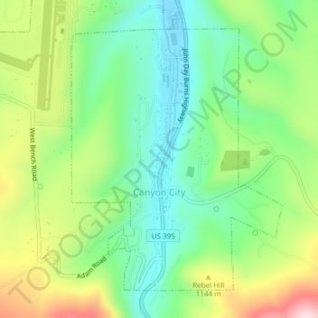
Nom : Carte topographique Canyon City, altitude, relief.
Lieu : Canyon City, Grant County, Oregon, 97820, United States (44.38124 -118.96065 44.40346 -118.93560)
Altitude moyenne : 1 078 m
Altitude minimum : 955 m
Altitude maximum : 1 293 m
The city is at an elevation of about 3,200 feet (980 m). Between Canyon City and Burns, to the south, Route 395 passes through parts of the Malheur National Forest. According to the United States Census Bureau, the town has a total area of 1.41 square miles (3.65 km2), all land.
Autres cartes topographiques
Cliquez sur une carte pour visualiser sa topographie, son altitude et son relief.
Granite
United States > Oregon > Grant County
Granite, Grant County, Oregon, United States
Altitude moyenne : 1 475 m
Robinsonville
United States > Oregon > Grant County
Robinsonville, Grant County, Oregon, United States
Altitude moyenne : 1 858 m
Austin
United States > Oregon > Grant County
Austin, Grant County, Oregon, United States
Altitude moyenne : 1 312 m
Monument
United States > Oregon > Grant County
Monument, Grant County, Oregon, United States
Altitude moyenne : 640 m
Kimberly
United States > Oregon > Grant County
Kimberly, Grant County, Oregon, United States
Altitude moyenne : 711 m
John Day
United States > Oregon > Grant County
John Day, Grant County, Oregon, 97845, United States
Altitude moyenne : 1 047 m
Desolation Butte
United States > Oregon > Grant County
Desolation Butte, Grant County, Oregon, United States
Altitude moyenne : 1 949 m
Rabbit Ears
United States > Oregon > Grant County
Rabbit Ears, Grant County, Oregon, United States
Altitude moyenne : 2 285 m
Prairie City
United States > Oregon > Grant County > Prairie City
Prairie City, Grant County, Oregon, United States
Altitude moyenne : 1 104 m