
Carte topographique John Day
Carte interactive
Cliquez sur la carte pour afficher l’altitude.
À propos de cette carte
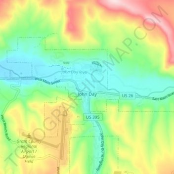
Nom : Carte topographique John Day, altitude, relief.
Lieu : John Day, Grant County, Oregon, 97845, United States (44.40318 -118.98629 44.43233 -118.91518)
Altitude moyenne : 1 047 m
Altitude minimum : 918 m
Altitude maximum : 1 254 m
John Day is at an elevation of 3,087 feet (941 m). According to the United States Census Bureau, the city has a total area of 1.87 square miles (4.84 km2), all land.
Autres cartes topographiques
Cliquez sur une carte pour visualiser sa topographie, son altitude et son relief.
Granite
United States > Oregon > Grant County
Granite, Grant County, Oregon, United States
Altitude moyenne : 1 475 m
Robinsonville
United States > Oregon > Grant County
Robinsonville, Grant County, Oregon, United States
Altitude moyenne : 1 858 m
Austin
United States > Oregon > Grant County
Austin, Grant County, Oregon, United States
Altitude moyenne : 1 312 m
Monument
United States > Oregon > Grant County
Monument, Grant County, Oregon, United States
Altitude moyenne : 640 m
Kimberly
United States > Oregon > Grant County
Kimberly, Grant County, Oregon, United States
Altitude moyenne : 711 m
Desolation Butte
United States > Oregon > Grant County
Desolation Butte, Grant County, Oregon, United States
Altitude moyenne : 1 949 m
Rabbit Ears
United States > Oregon > Grant County
Rabbit Ears, Grant County, Oregon, United States
Altitude moyenne : 2 285 m
Prairie City
United States > Oregon > Grant County > Prairie City
Prairie City, Grant County, Oregon, United States
Altitude moyenne : 1 104 m
Canyon City
United States > Oregon > Grant County
Canyon City, Grant County, Oregon, 97820, United States
Altitude moyenne : 1 078 m