
Carte topographique Lalaye
Carte interactive
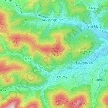
Cliquez sur la carte pour afficher l’altitude.
À propos de cette carte
Nom : Carte topographique Lalaye, altitude, relief.
Altitude moyenne : 409 m
Altitude minimum : 266 m
Altitude maximum : 699 m
Lalaye est située à 3 km en amont de la commune de Villé et sur la rive gauche du Giessen d'Urbeis. Elle a une surface de 818 ha. La commune est fermée au nord par l'arête de la Honel qui se maintient autour de 600 mètres d'altitude jusqu'au Blanc-Noyer qui domine la vallée du Giessen de Steige. À l'ouest, les deux ramifications du vallon de Charbes viennent buter sur les puissantes hauteurs du Mont (822 m) qui précèdent le replat où s'est installé le hameau du Climont. Au sud enfin, une ligne de crêtes moins élevé court du Kohlberg (500 m) jusqu'à la Goutte Henri (610 m) et sépare le vallon de la vallée du Giessen proprement dite.
Autres cartes topographiques
Cliquez sur une carte pour visualiser sa topographie, son altitude et son relief.
Strasbourg
Strasbourg, Bas-Rhin, Grand Est, France métropolitaine, France
Altitude moyenne : 144 m
Duppigheim
Duppigheim, Molsheim, Bas-Rhin, Grand Est, France métropolitaine, 67120, France
Altitude moyenne : 159 m
Trüdersche
France > Grand Est > Bas-Rhin > Truchtersheim
Trüdersche, Truchtersheim, Saverne, Bas-Rhin, Grand Est, France métropolitaine, 67370, France
Altitude moyenne : 175 m
Wingersheim
France > Grand Est > Bas-Rhin > Wingersheim les Quatre Bans
Wingersheim, Wingersheim les Quatre Bans, Saverne, Bas-Rhin, Grand Est, France métropolitaine, 67170, France
Altitude moyenne : 185 m
Sessenheim
Sessenheim, Haguenau-Wissembourg, Bas-Rhin, Grand Est, France métropolitaine, 67770, France
Altitude moyenne : 120 m
Kirrwiller
Kirrwiller, Saverne, Bas-Rhin, Grand Est, France métropolitaine, 67330, France
Altitude moyenne : 213 m
Ergersheim
Ergersheim, Molsheim, Bas-Rhin, Grand Est, France métropolitaine, 67120, France
Altitude moyenne : 186 m
Marmoutier
Marmoutier, Saverne, Bas-Rhin, Grand Est, France métropolitaine, 67440, France
Altitude moyenne : 246 m
Betschdorf
Betschdorf, Haguenau-Wissembourg, Bas-Rhin, Grand Est, France métropolitaine, 67660, France
Altitude moyenne : 151 m
Port du Rhin
France > Grand Est > Bas-Rhin > Strasbourg
Port du Rhin, Strasbourg, Bas-Rhin, Grand Est, France métropolitaine, 67017, France
Altitude moyenne : 141 m
Bernardvillé
Bernardvillé, Sélestat-Erstein, Bas-Rhin, Grand Est, France métropolitaine, 67140, France
Altitude moyenne : 360 m
Muttersholtz
Muttersholtz, Sélestat-Erstein, Bas-Rhin, Grand Est, France métropolitaine, 67600, France
Altitude moyenne : 167 m
Hochfelden
France > Grand Est > Bas-Rhin > Hochfelden
Hochfelden, Saverne, Bas-Rhin, Grand Est, France métropolitaine, 67270, France
Altitude moyenne : 180 m
Heiligenberg
Heiligenberg, Molsheim, Bas-Rhin, Grand Est, France métropolitaine, 67190, France
Altitude moyenne : 264 m
Obersteinbach
Obersteinbach, Haguenau-Wissembourg, Bas-Rhin, Grand Est, France métropolitaine, 67510, France
Altitude moyenne : 322 m
Sarrewerden
Sarrewerden, Saverne, Bas-Rhin, Grand Est, France métropolitaine, 67260, France
Altitude moyenne : 274 m
Dossenheim-sur-Zinsel
Dossenheim-sur-Zinsel, Saverne, Bas-Rhin, Grand Est, France métropolitaine, 67330, France
Altitude moyenne : 246 m
Drachenbronn-Birlenbach
Drachenbronn-Birlenbach, Haguenau-Wissembourg, Bas-Rhin, Grand Est, France métropolitaine, 67160, France
Altitude moyenne : 225 m
Colroy-la-Roche
Colroy-la-Roche, Molsheim, Bas-Rhin, Grand Est, France métropolitaine, 67420, France
Altitude moyenne : 574 m
Harskirchen
Harskirchen, Saverne, Bas-Rhin, Grand Est, France métropolitaine, 67260, France
Altitude moyenne : 240 m
Étang de Fleckenstein
France > Grand Est > Bas-Rhin > Lembach
Étang de Fleckenstein, Lembach, Haguenau-Wissembourg, Bas-Rhin, Grand Est, France métropolitaine, 67510, France
Altitude moyenne : 304 m
Étang Gerig
France > Grand Est > Bas-Rhin > Ostwald
Étang Gerig, Ostwald, Strasbourg, Bas-Rhin, Grand Est, France métropolitaine, 67540, France
Altitude moyenne : 142 m
Saint-Jean-Saverne
Saint-Jean-Saverne, Saverne, Bas-Rhin, Grand Est, France métropolitaine, 67700, France
Altitude moyenne : 272 m
Eckwersheim
Eckwersheim, Strasbourg, Bas-Rhin, Grand Est, France métropolitaine, 67550, France
Altitude moyenne : 156 m
67117
France > Grand Est > Bas-Rhin > Hurtigheim
67117, Hurtigheim, Saverne, Bas-Rhin, Grand Est, France métropolitaine, France
Altitude moyenne : 175 m
Kaltenhouse
Kaltenhouse, Haguenau-Wissembourg, Bas-Rhin, Grand Est, France métropolitaine, 67240, France
Altitude moyenne : 142 m
Zinswiller
Zinswiller, Haguenau-Wissembourg, Bas-Rhin, Grand Est, France métropolitaine, 67110, France
Altitude moyenne : 240 m
Niederhaslach
Niederhaslach, Molsheim, Bas-Rhin, Grand Est, France métropolitaine, 67280, France
Altitude moyenne : 282 m
Natzwiller
Natzwiller, Molsheim, Bas-Rhin, Grand Est, France métropolitaine, 67130, France
Altitude moyenne : 705 m
Ernolsheim-Bruche
Ernolsheim-Bruche, Molsheim, Bas-Rhin, Grand Est, France métropolitaine, 67120, France
Altitude moyenne : 173 m