
Faire un don
Équipez-vous pour votre prochaine aventure :
En tant que Partenaire Amazon, ce site perçoit une commission sur les achats éligibles sans surcoût pour vous.
Carte topographique Kakheti
Cliquez sur la carte pour afficher l’altitude.
Faire un don
Équipez-vous pour votre prochaine aventure :
En tant que Partenaire Amazon, ce site perçoit une commission sur les achats éligibles sans surcoût pour vous.
Kakheti
The Kakheti Wine Region is located in the eastern part of Georgia and comprises two river basins, Iori and Alazani. These rivers have a significant influence on the character of Kakhetian wines. Kakheti is bordered on the west by another very important wine region of Georgia - Kartli. Together with the location, the climatic conditions of the region play an essential role in the formation of Kakheti wines. Kakheti vineyards are cultivated at an altitude of 250–800 meters above sea level. We can find both humid subtropicals as well as continental climates in the region. Kakheti terroir provides ideal conditions for both local varieties and international wine varieties as well. When talking about the Kakheti wine region, the first thing that comes to mind is Rkatsiteli and Saperavi grapes. These two wine varieties have become the face of the region and Georgia. With the increase in the awareness of Georgian wine, the interest in these varieties is growing, so do not be surprised if you encounter these Kakhetian wine varieties in different wine regions in the world.
Faire un don
Équipez-vous pour votre prochaine aventure :
En tant que Partenaire Amazon, ce site perçoit une commission sur les achats éligibles sans surcoût pour vous.
À propos de cette carte
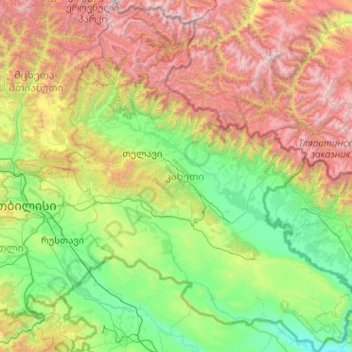
Nom : Carte topographique Kakheti, altitude, relief.
Lieu : Kakheti, Georgia (41.05513 45.02585 42.57397 46.73654)
Altitude moyenne : 1 191 m
Altitude minimum : 78 m
Altitude maximum : 4 345 m
Faire un don
Équipez-vous pour votre prochaine aventure :
En tant que Partenaire Amazon, ce site perçoit une commission sur les achats éligibles sans surcoût pour vous.
Autres cartes topographiques
Cliquez sur une carte pour visualiser sa topographie, son altitude et son relief.
Caucasus Mountains
Georgia > Mtskheta-Mtianeti > Dusheti Municipality > Chalisopeli
The climate of the Caucasus varies both vertically (according to elevation) and horizontally (by latitude and location). Temperature generally decreases as elevation rises. Average annual temperature in Sukhumi, Abkhazia at sea level is 15 °C (59 °F) while on the slopes of Mt.Kazbek at an elevation of 3,700…
Altitude moyenne : 2 188 m
Gudauri
Georgia > Mtskheta-Mtianeti > Kazbegi Municipality
Gudauri (Georgian: გუდაური) is a ski resort located on the south-facing plateau of The Greater Caucasus Mountain Range in Georgia. The resort is situated in the Kazbegi Municipality, along the Georgian Military Highway near the Jvari Pass, at an elevation of 2,200 meters (7,200 ft.) above sea…
Altitude moyenne : 2 161 m
Faire un don
Équipez-vous pour votre prochaine aventure :
En tant que Partenaire Amazon, ce site perçoit une commission sur les achats éligibles sans surcoût pour vous.
Gudauri
Georgia > Mtskheta-Mtianeti > Kazbegi Municipality
Gudauri (Georgian: გუდაური) is a ski resort located on the south-facing plateau of The Greater Caucasus Mountain Range in Georgia. The resort is situated in the Stepantsminda District, along the Georgian Military Highway near the Jvari Pass, at an elevation of 2,200 meters (7,200 ft.) above sea…
Altitude moyenne : 2 161 m
Darial Gorge
Georgia > Mtskheta-Mtianeti > Kazbegi Municipality
The Russian fort, Darial, which guarded this section of the Georgian Military Road, was built at the northern end of the gorge, at an altitude of 1,447 metres (4,747 ft).
Altitude moyenne : 1 783 m
Faire un don
Équipez-vous pour votre prochaine aventure :
En tant que Partenaire Amazon, ce site perçoit une commission sur les achats éligibles sans surcoût pour vous.
Jvari
Georgia > Samegrelo-Upper Svaneti > Tsalenjikha Municipality
Jvari (Georgian: ჯვარი) is a town in the northwestern Georgian province of Samegrelo-Zemo Svaneti. The town is situated at an altitude of 280 metres near the Magana River where it flows into the Enguri River; The town is divided in two with "Jvari" lying on the Zugdidi-Mestia highway, and Jvarzeni…
Altitude moyenne : 450 m
Faire un don
Équipez-vous pour votre prochaine aventure :
En tant que Partenaire Amazon, ce site perçoit une commission sur les achats éligibles sans surcoût pour vous.
Kveda Sairme
Georgia > Racha-Lechkhumi and Kvemo Svaneti > Tsageri Municipality
Altitude moyenne : 669 m
Faire un don
Équipez-vous pour votre prochaine aventure :
En tant que Partenaire Amazon, ce site perçoit une commission sur les achats éligibles sans surcoût pour vous.
Faire un don
Équipez-vous pour votre prochaine aventure :
En tant que Partenaire Amazon, ce site perçoit une commission sur les achats éligibles sans surcoût pour vous.
Caucasus Mountains
Georgia > Mtskheta-Mtianeti > Dusheti Municipality > Chalisopeli
The climate of the Caucasus varies both vertically (according to elevation) and horizontally (by latitude and location). Temperature generally decreases as elevation rises. Average annual temperature in Sokhumi, Abkhazia at sea level is 15 °C (59 °F) while on the slopes of Mt.Kazbek at an elevation of 3,700…
Altitude moyenne : 2 188 m
Senaki
Georgia > Samegrelo-Upper Svaneti > Senaki Municipality
Senaki (Georgian: სენაკი, senak'i; Mingrelian: სანაკი, sanak'i) is a city in Samegrelo-Zemo Svaneti region, western Georgia. It is located at around 42°16′8″N 42°4′45″E / 42.26889°N 42.07917°E / 42.26889; 42.07917 between the rivers Tekhura/i and Tsivi, at an…
Altitude moyenne : 80 m
Faire un don
Équipez-vous pour votre prochaine aventure :
En tant que Partenaire Amazon, ce site perçoit une commission sur les achats éligibles sans surcoût pour vous.
Nokalakevi (Tsikhegoji)
Georgia > Samegrelo-Upper Svaneti > Senaki Municipality > Gakhomela
Altitude moyenne : 158 m
Faire un don
Équipez-vous pour votre prochaine aventure :
En tant que Partenaire Amazon, ce site perçoit une commission sur les achats éligibles sans surcoût pour vous.
Faire un don
Équipez-vous pour votre prochaine aventure :
En tant que Partenaire Amazon, ce site perçoit une commission sur les achats éligibles sans surcoût pour vous.
Bakuriani
Georgia > Samtskhe-Javakheti > Borjomi Municipality
Bakuriani (Georgian: ბაკურიანი) is a daba and a ski resort in the Borjomi district of Georgia. It is located on the northern slope of the Trialeti Range, at an elevation of 1,700 meters (5,576 feet) above sea level.
Altitude moyenne : 1 756 m
Faire un don
Équipez-vous pour votre prochaine aventure :
En tant que Partenaire Amazon, ce site perçoit une commission sur les achats éligibles sans surcoût pour vous.
Faire un don
Équipez-vous pour votre prochaine aventure :
En tant que Partenaire Amazon, ce site perçoit une commission sur les achats éligibles sans surcoût pour vous.
Kveda Tkhilvana
Georgia > Autonomous Republic of Adjara > Khulo Municipality
Altitude moyenne : 1 635 m
Very steep, dangerous route
Georgia > Samegrelo-Upper Svaneti > Mestia Municipality
Altitude moyenne : 1 875 m
Faire un don
Équipez-vous pour votre prochaine aventure :
En tant que Partenaire Amazon, ce site perçoit une commission sur les achats éligibles sans surcoût pour vous.
Faire un don
Équipez-vous pour votre prochaine aventure :
En tant que Partenaire Amazon, ce site perçoit une commission sur les achats éligibles sans surcoût pour vous.
Faire un don
Équipez-vous pour votre prochaine aventure :
En tant que Partenaire Amazon, ce site perçoit une commission sur les achats éligibles sans surcoût pour vous.
Tbilisa Glacier
Georgia > Racha-Lechkhumi and Kvemo Svaneti > Oni Municipality
Altitude moyenne : 3 443 m
Shan
Georgia > Mtskheta-Mtianeti > Kazbegi Municipality
Mt. Shani (Ingush: Шанлоам, lit. ''icy mountain''; Georgian: შანი; Russian: Шан) also known as Shan and Shanloam is a mountain in the Caucasus. It has an elevation of 4,451 metres (14,603 ft) and is on the international border between Georgia and Ingushetia, Russia.
Altitude moyenne : 3 620 m
Faire un don
Équipez-vous pour votre prochaine aventure :
En tant que Partenaire Amazon, ce site perçoit une commission sur les achats éligibles sans surcoût pour vous.
Faire un don
Équipez-vous pour votre prochaine aventure :
En tant que Partenaire Amazon, ce site perçoit une commission sur les achats éligibles sans surcoût pour vous.
Mestia
Georgia > Samegrelo-Upper Svaneti > Mestia Municipality
Mestia (Georgian: მესტია IPA: [mestʼia]) is a highland townlet (daba) in northwest Georgia, at an elevation of 1,500 metres (4,921 feet) in the Caucasus Mountains.
Altitude moyenne : 1 761 m
Faire un don
Équipez-vous pour votre prochaine aventure :
En tant que Partenaire Amazon, ce site perçoit une commission sur les achats éligibles sans surcoût pour vous.
Mtirala
Georgia > Autonomous Republic of Adjara > Khelvachauri Municipality
Altitude moyenne : 1 000 m
Bakuriani
Georgia > Samtskhe-Javakheti > Borjomi Municipality
Bakuriani (Georgian: ბაკურიანი) is a daba and a ski resort in the Borjomi district of Georgia. It is located on the northern slope of the Trialeti Range, at an elevation of 1,700 meters (5,576 feet) above sea level.
Altitude moyenne : 1 756 m
Faire un don
Équipez-vous pour votre prochaine aventure :
En tant que Partenaire Amazon, ce site perçoit une commission sur les achats éligibles sans surcoût pour vous.
Shaori Reservoir
Georgia > Racha-Lechkhumi and Kvemo Svaneti > Ambrolauri Municipality > Kharistvala
Altitude moyenne : 1 281 m
Gudauri
Georgia > Mtskheta-Mtianeti > Kazbegi Municipality
Gudauri (Georgian: გუდაური) is a ski resort located on the south-facing plateau of The Greater Caucasus Mountain Range in Georgia. The resort is situated in the Kazbegi Municipality, along the Georgian Military Highway near the Jvari Pass, at an elevation of 2,200 meters (7,200 ft.) above sea…
Altitude moyenne : 2 161 m
Faire un don
Équipez-vous pour votre prochaine aventure :
En tant que Partenaire Amazon, ce site perçoit une commission sur les achats éligibles sans surcoût pour vous.
Waterfall at Stone Mining
Georgia > Autonomous Republic of Adjara > Kobuleti Municipality
Altitude moyenne : 484 m
Faire un don
Équipez-vous pour votre prochaine aventure :
En tant que Partenaire Amazon, ce site perçoit une commission sur les achats éligibles sans surcoût pour vous.
Faire un don
Équipez-vous pour votre prochaine aventure :
En tant que Partenaire Amazon, ce site perçoit une commission sur les achats éligibles sans surcoût pour vous.
Buba Glacier
Georgia > Racha-Lechkhumi and Kvemo Svaneti > Oni Municipality
Altitude moyenne : 3 398 m
Faire un don
Équipez-vous pour votre prochaine aventure :
En tant que Partenaire Amazon, ce site perçoit une commission sur les achats éligibles sans surcoût pour vous.
Twin Waterfalls
Georgia > Autonomous Republic of Adjara > Khelvachauri Municipality
Altitude moyenne : 1 079 m
Faire un don
Équipez-vous pour votre prochaine aventure :
En tant que Partenaire Amazon, ce site perçoit une commission sur les achats éligibles sans surcoût pour vous.
Shemokmedi
Georgia > Guria > Ozurgeti Municipality
Shemokmedi (Georgian: შემოქმედი) is a village in the Ozurgeti Municipality, Guria, Georgia. It is located in western Georgia, on the Bzhuzhi river, at elevation of 190 m above sea level, 7 km east of the city of Ozurgeti. The village is home to the late medieval Shemokmedi Monastery.
Altitude moyenne : 181 m
Cold Waterfall
Georgia > Autonomous Republic of Adjara > Khelvachauri Municipality > Sarpi
Altitude moyenne : 101 m
Makhuntseti waterfall
Georgia > Autonomous Republic of Adjara > Keda Municipality > Zeda Makhuntseti
Altitude moyenne : 354 m
Faire un don
Équipez-vous pour votre prochaine aventure :
En tant que Partenaire Amazon, ce site perçoit une commission sur les achats éligibles sans surcoût pour vous.
Mirveti Waterfall
Georgia > Autonomous Republic of Adjara > Khelvachauri Municipality > Mirveti
Altitude moyenne : 297 m
Merisi waterfall
Georgia > Autonomous Republic of Adjara > Keda Municipality > Gundauri
Altitude moyenne : 902 m
Faire un don
Équipez-vous pour votre prochaine aventure :
En tant que Partenaire Amazon, ce site perçoit une commission sur les achats éligibles sans surcoût pour vous.
Faire un don
Équipez-vous pour votre prochaine aventure :
En tant que Partenaire Amazon, ce site perçoit une commission sur les achats éligibles sans surcoût pour vous.