
Carte topographique Ruxton
Carte interactive
Cliquez sur la carte pour afficher l’altitude.
À propos de cette carte
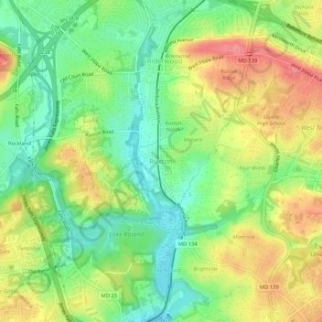
Nom : Carte topographique Ruxton, altitude, relief.
Lieu : Ruxton, Baltimore County, Maryland, 21139, United States (39.37804 -76.66486 39.41804 -76.62486)
Altitude moyenne : 105 m
Altitude minimum : 64 m
Altitude maximum : 157 m
Autres cartes topographiques
Cliquez sur une carte pour visualiser sa topographie, son altitude et son relief.
Dundalk
United States > Maryland > Baltimore County
Dundalk, Baltimore County, Maryland, 21222, United States
Altitude moyenne : 33 m
Lutherville
United States > Maryland > Baltimore County
Lutherville, Baltimore County, Maryland, 21204, United States
Altitude moyenne : 117 m
Towson
United States > Maryland > Baltimore County
Towson, Baltimore County, Maryland, 21252, United States
Altitude moyenne : 101 m
Parkville
United States > Maryland > Baltimore County
Parkville, Baltimore County, Maryland, 21234, United States
Altitude moyenne : 91 m
Baltimore Highlands
United States > Maryland > Baltimore County
Baltimore Highlands, Baltimore County, Maryland, 21225, United States
Altitude moyenne : 21 m
Baldwin
United States > Maryland > Baltimore County
Baldwin, Baltimore County, Maryland, 21082, United States
Altitude moyenne : 130 m
White Marsh
United States > Maryland > Baltimore County > White Marsh
White Marsh, Baltimore County, Maryland, United States
Altitude moyenne : 39 m
Middle River
United States > Maryland > Baltimore County > Middle River
Middle River, Baltimore County, Maryland, 21220, United States
Altitude moyenne : 13 m
Dundalk
United States > Maryland > Baltimore County > Dundalk
Dundalk, Baltimore County, Maryland, 21222, United States
Altitude moyenne : 6 m
Pikesville
United States > Maryland > Baltimore County > Pikesville
Pikesville, Baltimore County, Maryland, United States
Altitude moyenne : 135 m
Butler
United States > Maryland > Baltimore County > Butler
Butler, Baltimore County, Maryland, 21023, United States
Altitude moyenne : 134 m
Carney
United States > Maryland > Baltimore County > Oakleigh
Carney, Oakleigh, Baltimore County, Maryland, United States
Altitude moyenne : 103 m
Arbutus
United States > Maryland > Baltimore County > Arbutus
Arbutus, Baltimore County, Maryland, United States
Altitude moyenne : 42 m
Essex
United States > Maryland > Baltimore County > Essex
Essex, Baltimore County, Maryland, 21221, United States
Altitude moyenne : 6 m
Towson
United States > Maryland > Baltimore County > Riderwood
Towson, Riderwood, Baltimore County, Maryland, United States
Altitude moyenne : 114 m
Catonsville
United States > Maryland > Baltimore County > Catonsville
Catonsville, Baltimore County, Maryland, 21228, United States
Altitude moyenne : 104 m
Bird River
United States > Maryland > Baltimore County > Bowleys Quarters
Bird River, Bowleys Quarters, Baltimore County, Maryland, United States
Altitude moyenne : 4 m
Glen Falls
United States > Maryland > Baltimore County > Glen Falls
Glen Falls, Baltimore County, Maryland, United States
Altitude moyenne : 167 m
Parkville
United States > Maryland > Baltimore County > Parkville
Parkville, Baltimore County, Maryland, 21234, United States
Altitude moyenne : 111 m
Catonsville
United States > Maryland > Baltimore County > Catonsville
Catonsville, Baltimore County, Maryland, United States
Altitude moyenne : 105 m