
Carte topographique Dundalk
Carte interactive
Cliquez sur la carte pour afficher l’altitude.
À propos de cette carte
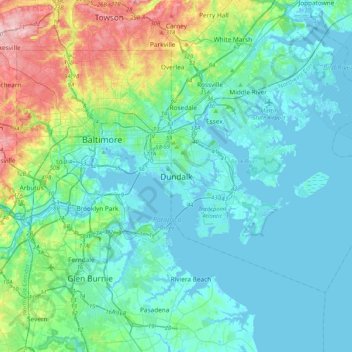
Nom : Carte topographique Dundalk, altitude, relief.
Lieu : Dundalk, Baltimore County, Maryland, 21222, United States (39.09741 -76.68367 39.41741 -76.36367)
Altitude moyenne : 33 m
Altitude minimum : -3 m
Altitude maximum : 173 m
Most of Dundalk is flat and very near sea level, with a few small hills close to the city of Baltimore to the west. Dundalk is part of the Atlantic Coastal Plain. Elevations range from sea level on the shore of the Chesapeake Bay to approximately 40 feet (12 m) above sea level along the northern reaches of Dundalk Avenue and North Point Boulevard.
Autres cartes topographiques
Cliquez sur une carte pour visualiser sa topographie, son altitude et son relief.
Lutherville
United States > Maryland > Baltimore County
Lutherville, Baltimore County, Maryland, 21204, United States
Altitude moyenne : 117 m
Towson
United States > Maryland > Baltimore County
Towson, Baltimore County, Maryland, 21252, United States
Altitude moyenne : 101 m
Parkville
United States > Maryland > Baltimore County
Parkville, Baltimore County, Maryland, 21234, United States
Altitude moyenne : 91 m
Baltimore Highlands
United States > Maryland > Baltimore County
Baltimore Highlands, Baltimore County, Maryland, 21225, United States
Altitude moyenne : 21 m
Ruxton
United States > Maryland > Baltimore County
Ruxton, Baltimore County, Maryland, 21139, United States
Altitude moyenne : 105 m
Baldwin
United States > Maryland > Baltimore County
Baldwin, Baltimore County, Maryland, 21082, United States
Altitude moyenne : 130 m
White Marsh
United States > Maryland > Baltimore County > White Marsh
White Marsh, Baltimore County, Maryland, United States
Altitude moyenne : 39 m
Middle River
United States > Maryland > Baltimore County > Middle River
Middle River, Baltimore County, Maryland, 21220, United States
Altitude moyenne : 13 m
Dundalk
United States > Maryland > Baltimore County > Dundalk
Dundalk, Baltimore County, Maryland, 21222, United States
Altitude moyenne : 6 m
Pikesville
United States > Maryland > Baltimore County > Pikesville
Pikesville, Baltimore County, Maryland, United States
Altitude moyenne : 135 m
Butler
United States > Maryland > Baltimore County > Butler
Butler, Baltimore County, Maryland, 21023, United States
Altitude moyenne : 134 m
Carney
United States > Maryland > Baltimore County > Oakleigh
Carney, Oakleigh, Baltimore County, Maryland, United States
Altitude moyenne : 103 m
Arbutus
United States > Maryland > Baltimore County > Arbutus
Arbutus, Baltimore County, Maryland, United States
Altitude moyenne : 42 m
Essex
United States > Maryland > Baltimore County > Essex
Essex, Baltimore County, Maryland, 21221, United States
Altitude moyenne : 6 m
Towson
United States > Maryland > Baltimore County > Riderwood
Towson, Riderwood, Baltimore County, Maryland, United States
Altitude moyenne : 114 m
Catonsville
United States > Maryland > Baltimore County > Catonsville
Catonsville, Baltimore County, Maryland, 21228, United States
Altitude moyenne : 104 m
Bird River
United States > Maryland > Baltimore County > Bowleys Quarters
Bird River, Bowleys Quarters, Baltimore County, Maryland, United States
Altitude moyenne : 4 m
Glen Falls
United States > Maryland > Baltimore County > Glen Falls
Glen Falls, Baltimore County, Maryland, United States
Altitude moyenne : 167 m
Parkville
United States > Maryland > Baltimore County > Parkville
Parkville, Baltimore County, Maryland, 21234, United States
Altitude moyenne : 111 m
Catonsville
United States > Maryland > Baltimore County > Catonsville
Catonsville, Baltimore County, Maryland, United States
Altitude moyenne : 105 m