
Carte topographique Ban Tha Khum Ngoen
Carte interactive
Cliquez sur la carte pour afficher l’altitude.
À propos de cette carte
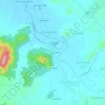
Nom : Carte topographique Ban Tha Khum Ngoen, altitude, relief.
Lieu : Ban Tha Khum Ngoen, Tha Khum Ngoen, Lamphun Province, Thailand (18.40581 98.93875 18.44581 98.97875)
Altitude moyenne : 342 m
Altitude minimum : 315 m
Altitude maximum : 538 m
Autres cartes topographiques
Cliquez sur une carte pour visualiser sa topographie, son altitude et son relief.
Tha Pla Duk
Tha Pla Duk, Lamphun Province, Thailand
Altitude moyenne : 527 m
Ping River
Thailand > Lamphun Province > Ban Bor Kao > Ban Nong Sa Lik
Ping River, Nong Salik Dam Project, Ban Nong Sa Lik, Ban Bor Kao, Mae Raeng, Lamphun Province, 51120, Thailand
Altitude moyenne : 288 m
Tha Sop Sao
Thailand > Lamphun Province > Tha Sop Sao
Tha Sop Sao, Lamphun Province, Thailand
Altitude moyenne : 450 m
Huai Sai Dai
Thailand > Lamphun Province > Huai Sai Dai
Huai Sai Dai, Lamphun Province, Thailand
Altitude moyenne : 325 m
Lamphun
Lamphun, Wiang Yong, Lamphun Province, 51000, Thailand
Altitude moyenne : 293 m