
Carte topographique Tha Pla Duk
Carte interactive
Cliquez sur la carte pour afficher l’altitude.
À propos de cette carte
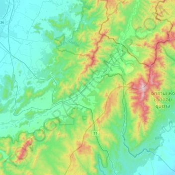
Nom : Carte topographique Tha Pla Duk, altitude, relief.
Lieu : Tha Pla Duk, Lamphun Province, Thailand (18.33225 99.03582 18.65225 99.35582)
Altitude moyenne : 527 m
Altitude minimum : 275 m
Altitude maximum : 1 349 m
Autres cartes topographiques
Cliquez sur une carte pour visualiser sa topographie, son altitude et son relief.
Ban Tha Khum Ngoen
Ban Tha Khum Ngoen, Tha Khum Ngoen, Lamphun Province, Thailand
Altitude moyenne : 342 m
Ping River
Thailand > Lamphun Province > Ban Bor Kao > Ban Nong Sa Lik
Ping River, Nong Salik Dam Project, Ban Nong Sa Lik, Ban Bor Kao, Mae Raeng, Lamphun Province, 51120, Thailand
Altitude moyenne : 288 m
Tha Sop Sao
Thailand > Lamphun Province > Tha Sop Sao
Tha Sop Sao, Lamphun Province, Thailand
Altitude moyenne : 450 m
Huai Sai Dai
Thailand > Lamphun Province > Huai Sai Dai
Huai Sai Dai, Lamphun Province, Thailand
Altitude moyenne : 325 m
Lamphun
Lamphun, Wiang Yong, Lamphun Province, 51000, Thailand
Altitude moyenne : 293 m