
Carte topographique Clark County
Carte interactive
Cliquez sur la carte pour afficher l’altitude.
À propos de cette carte
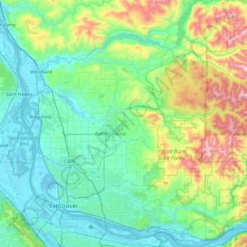
Nom : Carte topographique Clark County, altitude, relief.
Lieu : Clark County, Washington, United States of America (45.54372 -122.79625 46.05972 -122.24453)
Altitude moyenne : 266 m
Altitude minimum : -3 m
Altitude maximum : 1 318 m
Many lakes border the river in the lowlands near Ridgefield, including Vancouver Lake. Eastern and northern Clark County contain forested foothills of the Cascade Mountains, rising to an elevation of 4,000 feet (1,200 m) on the border with Skamania County. Larch Mountain is the county's highest free-standing peak.
Autres cartes topographiques
Cliquez sur une carte pour visualiser sa topographie, son altitude et son relief.
East Renton Highlands
United States of America > Washington > East Renton Highlands > East Renton Highlands
East Renton Highlands, King County, Washington, United States of America
Altitude moyenne : 159 m
Clyde Hill
United States of America > Washington > Clyde Hill > Clyde Hill
Clyde Hill, King County, Washington, United States of America
Altitude moyenne : 48 m
Cedar Creek Falls
United States of America > Washington
Cedar Creek Falls, Clark County, Washington, United States of America
Altitude moyenne : 440 m
Douglas County
United States of America > Washington
Douglas County, Washington, United States of America
Altitude moyenne : 634 m
Bellingham
United States of America > Washington > Bellingham
Bellingham, Whatcom County, Washington, United States of America
Altitude moyenne : 89 m
Christmas Creek
United States of America > Washington
Christmas Creek, Jefferson County, Washington, United States of America
Altitude moyenne : 242 m
Western Junction
United States of America > Washington > Western Junction
Western Junction, Thurston County, Washington, United States of America
Altitude moyenne : 114 m
Danville
United States of America > Washington > Maple Valley > Danville
Danville, Maple Valley, King County, Washington, 98038, United States of America
Altitude moyenne : 174 m
Cheney
United States of America > Washington > Cheney
Cheney, Spokane County, Washington, 99024, United States of America
Altitude moyenne : 725 m
Alice Creek
United States of America > Washington
Alice Creek, King County, Washington, United States of America
Altitude moyenne : 999 m
Bellevue
United States of America > Washington > Bellevue
Bellevue, King County, Washington, 98004-4452, United States of America
Altitude moyenne : 88 m
West Kelso
United States of America > Washington > Kelso > West Kelso
West Kelso, Kelso, Cowlitz County, Washington, 98626, United States of America
Altitude moyenne : 26 m
Mount Lindsay
United States of America > Washington
Mount Lindsay, King County, Washington, United States of America
Altitude moyenne : 1 065 m
Mac's Cove
United States of America > Washington > Cornet
Mac's Cove, Discovery Trail, Cornet, Island County, Washington, United States of America
Altitude moyenne : 25 m
Cathcart
United States of America > Washington > Cathcart
Cathcart, Snohomish County, Washington, 98296, United States of America
Altitude moyenne : 105 m
Deception Pass
United States of America > Washington > Rosario Beach
Deception Pass, Deception Pass Bridge, Deception Pass Shores, Rosario Beach, Skagit County, Washington, 98221, United States of America
Altitude moyenne : 28 m
Tukwila
United States of America > Washington > Tukwila
Tukwila, King County, Washington, United States of America
Altitude moyenne : 59 m
Duvall
United States of America > Washington > Duvall
Duvall, King County, Washington, United States of America
Altitude moyenne : 50 m
Walla Walla
United States of America > Washington > Walla Walla
Walla Walla, Walla Walla County, Washington, United States of America
Altitude moyenne : 297 m