
Carte topographique Laurier
Carte interactive
Cliquez sur la carte pour afficher l’altitude.
À propos de cette carte
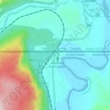
Nom : Carte topographique Laurier, altitude, relief.
Lieu : Laurier, Ferry County, Washington, 99146, United States (48.97879 -118.24418 49.01879 -118.20418)
Altitude moyenne : 604 m
Altitude minimum : 433 m
Altitude maximum : 1 301 m
Autres cartes topographiques
Cliquez sur une carte pour visualiser sa topographie, son altitude et son relief.
Keller
United States > Washington > Ferry County
Keller, Ferry County, Washington, 99140, United States
Altitude moyenne : 536 m
Inchelium
United States > Washington > Ferry County
Inchelium, Ferry County, Washington, United States
Altitude moyenne : 639 m
Danville
United States > Washington > Ferry County
Danville, Ferry County, Washington, 99121, United States
Altitude moyenne : 638 m
Malo
United States > Washington > Ferry County
Malo, Ferry County, Washington, 99160, United States
Altitude moyenne : 788 m
Orient
United States > Washington > Ferry County
Orient, Ferry County, Washington, United States
Altitude moyenne : 598 m
Republic
United States > Washington > Ferry County
Republic, Ferry County, Washington, United States
Altitude moyenne : 826 m
Curlew
United States > Washington > Ferry County
Curlew, Ferry County, Washington, United States
Altitude moyenne : 672 m
Wiseman Island
United States > Washington > Ferry County > Pollard
Wiseman Island, Pollard, Ferry County, Washington, United States
Altitude moyenne : 777 m