
Carte topographique Curlew
Carte interactive
Cliquez sur la carte pour afficher l’altitude.
À propos de cette carte
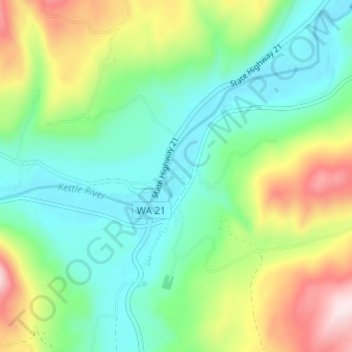
Nom : Carte topographique Curlew, altitude, relief.
Lieu : Curlew, Ferry County, Washington, United States (48.86545 -118.61947 48.90545 -118.57947)
Altitude moyenne : 672 m
Altitude minimum : 533 m
Altitude maximum : 969 m
Curlew is located at the confluence of Long Alec Creek and the Kettle River. Its elevation is 1,800 feet (550 m) above sea level. Via State Route 21, it is 21 miles (34 km) north of Republic, the Ferry County seat, and 10 miles (16 km) south of the Canadian border.
Autres cartes topographiques
Cliquez sur une carte pour visualiser sa topographie, son altitude et son relief.
Keller
United States > Washington > Ferry County
Keller, Ferry County, Washington, 99140, United States
Altitude moyenne : 536 m
Inchelium
United States > Washington > Ferry County
Inchelium, Ferry County, Washington, United States
Altitude moyenne : 639 m
Laurier
United States > Washington > Ferry County
Laurier, Ferry County, Washington, 99146, United States
Altitude moyenne : 604 m
Danville
United States > Washington > Ferry County
Danville, Ferry County, Washington, 99121, United States
Altitude moyenne : 638 m
Malo
United States > Washington > Ferry County
Malo, Ferry County, Washington, 99160, United States
Altitude moyenne : 788 m
Orient
United States > Washington > Ferry County
Orient, Ferry County, Washington, United States
Altitude moyenne : 598 m
Republic
United States > Washington > Ferry County
Republic, Ferry County, Washington, United States
Altitude moyenne : 826 m
Wiseman Island
United States > Washington > Ferry County > Pollard
Wiseman Island, Pollard, Ferry County, Washington, United States
Altitude moyenne : 777 m