
Faire un don
Équipez-vous pour votre prochaine aventure :
En tant que Partenaire Amazon, ce site perçoit une commission sur les achats éligibles sans surcoût pour vous.
Carte topographique Pacentro
Cliquez sur la carte pour afficher l’altitude.
Faire un don
Équipez-vous pour votre prochaine aventure :
En tant que Partenaire Amazon, ce site perçoit une commission sur les achats éligibles sans surcoût pour vous.
À propos de cette carte
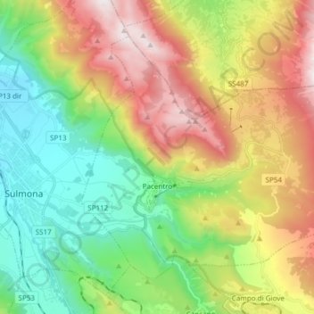
Nom : Carte topographique Pacentro, altitude, relief.
Lieu : Pacentro, L'Aquila, Italy (42.01718 13.95448 42.10344 14.10494)
Altitude moyenne : 998 m
Altitude minimum : 345 m
Altitude maximum : 2 018 m
Faire un don
Équipez-vous pour votre prochaine aventure :
En tant que Partenaire Amazon, ce site perçoit une commission sur les achats éligibles sans surcoût pour vous.
Autres cartes topographiques
Cliquez sur une carte pour visualiser sa topographie, son altitude et son relief.
Apennine Mountains
A separate branch, the Apuan Alps, goes southwest, bordering the coast south of La Spezia. Whether they are to be considered part of the Apennines is a matter of opinion; certainly, they are part of the Apennine System. Topographically only the valley of the River Serchio, which running parallel to the coast…
Altitude moyenne : 1 735 m
Faire un don
Équipez-vous pour votre prochaine aventure :
En tant que Partenaire Amazon, ce site perçoit une commission sur les achats éligibles sans surcoût pour vous.
Rocca Calascio
At an elevation of around 1,460 metres (4,790 ft), the castle is the highest fortress in the Apennines. Built of stone and masonry exclusively for military purposes and intended only to accommodate troops and never as a residence for nobles, the fortress overlooks the Plain of Navelli at one of the highest…
Altitude moyenne : 1 171 m
Faire un don
Équipez-vous pour votre prochaine aventure :
En tant que Partenaire Amazon, ce site perçoit une commission sur les achats éligibles sans surcoût pour vous.
Rocca Calascio
At an elevation of 1,512 metres (4,961 ft), the castle is the highest fortress in the Apennines. Built of stone and masonry exclusively for military purposes and intended only to accommodate troops and never as residence for nobles, the fortress overlooks the Plain of Navelli at one of the highest points in…
Altitude moyenne : 1 171 m