
Carte topographique Independence Charter Township
Carte interactive
Cliquez sur la carte pour afficher l’altitude.
À propos de cette carte
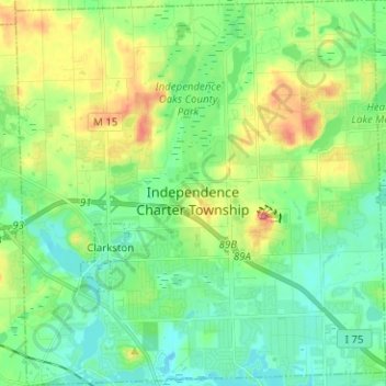
Nom : Carte topographique Independence Charter Township, altitude, relief.
Altitude moyenne : 318 m
Altitude minimum : 288 m
Altitude maximum : 385 m
Independence Township is located along the Hillsdale-Lapeer Moraine Range. The highest hill along that range in Independence Township is Pine Knob, at 1,221 feet. It is also the highest point in Southeastern Michigan. Only three miles away is Waterford Hill, the second highest hill in Independence Township with an elevation of 1,150 feet. Atop Waterford Hill is Olympus Circle, the highest elevation of any residential street in Independence Township.
Autres cartes topographiques
Cliquez sur une carte pour visualiser sa topographie, son altitude et son relief.
Lake Orion
United States > Michigan > Oakland County
Lake Orion, Oakland County, Michigan, 48362, United States
Altitude moyenne : 303 m
White Lake Charter Township
United States > Michigan > Oakland County
White Lake Charter Township, Oakland County, Michigan, United States
Altitude moyenne : 303 m
Bloomfield Hills
United States > Michigan > Oakland County
Bloomfield Hills, Oakland County, Michigan, 48304, United States
Altitude moyenne : 261 m
Highland Charter Township
United States > Michigan > Oakland County
Highland Charter Township, Oakland County, Michigan, 48357, United States
Altitude moyenne : 315 m
Rochester
United States > Michigan > Oakland County
Rochester, Oakland County, Michigan, United States
Altitude moyenne : 242 m
Troy
United States > Michigan > Oakland County
Troy, Oakland County, Michigan, United States
Altitude moyenne : 221 m
Walled Lake
United States > Michigan > Oakland County
Walled Lake, Oakland County, Michigan, United States
Altitude moyenne : 287 m
Greens Lake
United States > Michigan > Oakland County
Greens Lake, Oakland County, Michigan, United States
Altitude moyenne : 309 m
Oakley Park
United States > Michigan > Oakland County > Commerce Charter Township
Oakley Park, Commerce Charter Township, Oakland County, Michigan, 48390, United States
Altitude moyenne : 282 m
Rossman Lake
United States > Michigan > Oakland County
Rossman Lake, Oakland County, Michigan, United States
Altitude moyenne : 314 m
Southfield
United States > Michigan > Oakland County
Southfield, Oakland County, Michigan, United States
Altitude moyenne : 210 m
Huntington Woods
United States > Michigan > Oakland County
Huntington Woods, Oakland County, Michigan, 48070, United States
Altitude moyenne : 204 m
Keego Harbor
United States > Michigan > Oakland County
Keego Harbor, Oakland County, Michigan, United States
Altitude moyenne : 286 m
Auburn Hills
United States > Michigan > Oakland County
Auburn Hills, Oakland County, Michigan, 48326, United States
Altitude moyenne : 284 m
Wixom
United States > Michigan > Oakland County > Wixom
Wixom, Oakland County, Michigan, United States
Altitude moyenne : 288 m
Novi
United States > Michigan > Oakland County
Novi, Oakland County, Michigan, United States
Altitude moyenne : 280 m
Pleasant Ridge
United States > Michigan > Oakland County > Pleasant Ridge
Pleasant Ridge, Oakland County, Michigan, United States
Altitude moyenne : 201 m
Royal Oak
United States > Michigan > Oakland County
Royal Oak, Oakland County, Michigan, United States
Altitude moyenne : 203 m
South Lyon
United States > Michigan > Oakland County > South Lyon
South Lyon, Oakland County, Michigan, United States
Altitude moyenne : 282 m
Orion Charter Township
United States > Michigan > Oakland County
Orion Charter Township, Oakland County, Michigan, United States
Altitude moyenne : 306 m
Lakeville
United States > Michigan > Oakland County > Lakeville
Lakeville, Oakland County, Michigan, 48366, United States
Altitude moyenne : 299 m
Pontiac
United States > Michigan > Oakland County
Pontiac, Oakland County, Michigan, United States
Altitude moyenne : 290 m