
Carte topographique Rochester
Carte interactive
Cliquez sur la carte pour afficher l’altitude.
À propos de cette carte
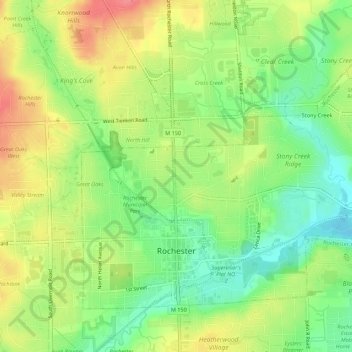
Nom : Carte topographique Rochester, altitude, relief.
Lieu : Rochester, Oakland County, Michigan, United States (42.67394 -83.14860 42.70440 -83.09382)
Altitude moyenne : 242 m
Altitude minimum : 208 m
Altitude maximum : 281 m
Autres cartes topographiques
Cliquez sur une carte pour visualiser sa topographie, son altitude et son relief.
Independence Charter Township
United States > Michigan > Oakland County
Independence Charter Township, Oakland County, Michigan, United States
Altitude moyenne : 318 m
Lake Orion
United States > Michigan > Oakland County
Lake Orion, Oakland County, Michigan, 48362, United States
Altitude moyenne : 303 m
White Lake Charter Township
United States > Michigan > Oakland County
White Lake Charter Township, Oakland County, Michigan, United States
Altitude moyenne : 303 m
Bloomfield Hills
United States > Michigan > Oakland County
Bloomfield Hills, Oakland County, Michigan, 48304, United States
Altitude moyenne : 261 m
Highland Charter Township
United States > Michigan > Oakland County
Highland Charter Township, Oakland County, Michigan, 48357, United States
Altitude moyenne : 315 m
Troy
United States > Michigan > Oakland County
Troy, Oakland County, Michigan, United States
Altitude moyenne : 221 m
Walled Lake
United States > Michigan > Oakland County
Walled Lake, Oakland County, Michigan, United States
Altitude moyenne : 287 m
Greens Lake
United States > Michigan > Oakland County
Greens Lake, Oakland County, Michigan, United States
Altitude moyenne : 309 m
Oakley Park
United States > Michigan > Oakland County > Commerce Charter Township
Oakley Park, Commerce Charter Township, Oakland County, Michigan, 48390, United States
Altitude moyenne : 282 m
Rossman Lake
United States > Michigan > Oakland County
Rossman Lake, Oakland County, Michigan, United States
Altitude moyenne : 314 m
Southfield
United States > Michigan > Oakland County
Southfield, Oakland County, Michigan, United States
Altitude moyenne : 210 m
Huntington Woods
United States > Michigan > Oakland County
Huntington Woods, Oakland County, Michigan, 48070, United States
Altitude moyenne : 204 m
Keego Harbor
United States > Michigan > Oakland County
Keego Harbor, Oakland County, Michigan, United States
Altitude moyenne : 286 m
Auburn Hills
United States > Michigan > Oakland County
Auburn Hills, Oakland County, Michigan, 48326, United States
Altitude moyenne : 284 m
Wixom
United States > Michigan > Oakland County > Wixom
Wixom, Oakland County, Michigan, United States
Altitude moyenne : 288 m
Novi
United States > Michigan > Oakland County
Novi, Oakland County, Michigan, United States
Altitude moyenne : 280 m
Pleasant Ridge
United States > Michigan > Oakland County > Pleasant Ridge
Pleasant Ridge, Oakland County, Michigan, United States
Altitude moyenne : 201 m
Royal Oak
United States > Michigan > Oakland County
Royal Oak, Oakland County, Michigan, United States
Altitude moyenne : 203 m
South Lyon
United States > Michigan > Oakland County > South Lyon
South Lyon, Oakland County, Michigan, United States
Altitude moyenne : 282 m
Orion Charter Township
United States > Michigan > Oakland County
Orion Charter Township, Oakland County, Michigan, United States
Altitude moyenne : 306 m
Lakeville
United States > Michigan > Oakland County > Lakeville
Lakeville, Oakland County, Michigan, 48366, United States
Altitude moyenne : 299 m
Pontiac
United States > Michigan > Oakland County
Pontiac, Oakland County, Michigan, United States
Altitude moyenne : 290 m