
Carte topographique Motiti Island
Carte interactive
Cliquez sur la carte pour afficher l’altitude.
À propos de cette carte
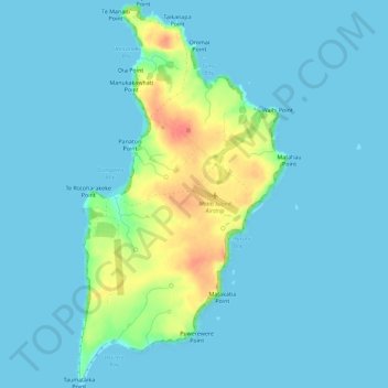
Nom : Carte topographique Motiti Island, altitude, relief.
Lieu : Motiti Island, Tauranga, Bay of Plenty, New Zealand (-37.64740 176.40678 -37.60209 176.43812)
Altitude moyenne : 10 m
Altitude minimum : 0 m
Altitude maximum : 62 m
Autres cartes topographiques
Cliquez sur une carte pour visualiser sa topographie, son altitude et son relief.
Tauranga
New Zealand > Bay of Plenty > Tauranga
Tauranga, Tauranga City, Bay of Plenty, New Zealand
Altitude moyenne : 10 m
Moturiki Island (Leisure Island)
New Zealand > Bay of Plenty > Tauranga
Moturiki Island (Leisure Island), Tauranga, Bay of Plenty, New Zealand
Altitude moyenne : 8 m
Wairoa River
New Zealand > Bay of Plenty > Tauranga
Wairoa River, Tauranga, Tauranga City, Bay of Plenty, 3171, New Zealand
Altitude moyenne : 65 m
Lake Aroarotamahine
New Zealand > Bay of Plenty > Tauranga
Lake Aroarotamahine, Tauranga, Tauranga City, Bay of Plenty, New Zealand
Altitude moyenne : 82 m
Mayor Island
New Zealand > Bay of Plenty > Tauranga
Mayor Island, Tauranga, Bay of Plenty, New Zealand
Altitude moyenne : 71 m
Yatton Park
New Zealand > Bay of Plenty > Tauranga
Yatton Park, Begonia Way, Merivale, Tauranga, Tauranga City, Bay of Plenty, 3112, New Zealand
Altitude moyenne : 19 m