
Carte topographique Zhejiang
Carte interactive
Cliquez sur la carte pour afficher l’altitude.
À propos de cette carte
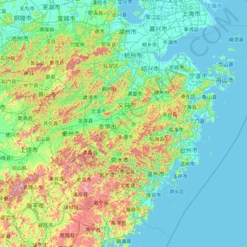
Nom : Carte topographique Zhejiang, altitude, relief.
Lieu : Zhejiang, China (26.85910 118.02241 31.18258 123.39362)
Altitude moyenne : 223 m
Altitude minimum : -2 m
Altitude maximum : 2 037 m
Zhejiang consists mostly of hills, which account for about 70% of its total area, with higher altitudes towards the south and the west. Zhejiang also has a longer coastline than any other mainland province of China. The Qiantang River runs through the province, from which it derives its name. Included in the province are three thousand islands, the most in China. The capital Hangzhou marks the end of the Grand Canal and lies on Hangzhou Bay on the north of Zhejiang, which separates Shanghai and Ningbo. The bay contains many small islands collectively called the Zhoushan Islands.
Autres cartes topographiques
Cliquez sur une carte pour visualiser sa topographie, son altitude et son relief.
Meizhou Island
Meizhou Island, Xiuyu District, Putian City, Fujian, China
Altitude moyenne : 3 m
Lihuo
China > Guangxi > Naliang Township
Lihuo, Naliang Township, Fangcheng District, Fangchenggang City, Guangxi, China
Altitude moyenne : 233 m
Bagui
China > Guangxi > Tianlin County
Bagui, Tianlin County, Baise, Guangxi, China
Altitude moyenne : 574 m
Macau
China > Macau > São Lourenço
Macau, São Lourenço, Municipality of Macau, Macau, 519020, China
Altitude moyenne : 17 m
Baotou City
Baotou City, Inner Mongolia, 014000, China
Altitude moyenne : 1 316 m
19
China > Hong Kong > Hong Kong Island
19, Government Hill, Central, Central and Western District, Hong Kong Island, Hong Kong, China, Hong Kong Park
Altitude moyenne : 143 m
Dalin
China > Inner Mongolia > Tongliao City
Dalin, Horqin District, Tongliao City, Inner Mongolia, China
Altitude moyenne : 161 m
Jianzhu Subdistrict
China > Heilongjiang > Harbin
Jianzhu Subdistrict, Xiangfang District, Harbin, Heilongjiang, 150000, China
Altitude moyenne : 163 m
Xinwu District
Xinwu District, Wuxi City, Jiangsu, 214000, China
Altitude moyenne : 7 m
Lidong
China > Guangdong Province > Yunan County
Lidong, Yunan County, Yunfu City, Guangdong Province, China
Altitude moyenne : 277 m
Chongchuan District
Chongchuan District, Nantong, Jiangsu, 226000, China
Altitude moyenne : 3 m
Bagua Island
China > Jiangsu > Nanjing City
Bagua Island, Nanjing City, Jiangsu, China
Altitude moyenne : 7 m
Golog Tibetan Autonomous Prefecture
China > Qinghai > Gadê County
Golog Tibetan Autonomous Prefecture, Gadê County, Golog Tibetan Autonomous Prefecture, Qinghai, China
Altitude moyenne : 4 340 m
Anda
China > Heilongjiang > Anda City > Anda
Anda, 新兴街道办事处, Anda City, Suihua City, Heilongjiang, China
Altitude moyenne : 150 m
Lianyungang City
China > Jiangsu > Lianyungang City
Lianyungang City, Jiangsu, China
Altitude moyenne : 19 m
Turpan Depression
China > Xinjiang > Gaochang District
Turpan Depression, Gaochang District, Turpan, Xinjiang, China
Altitude moyenne : -152 m