
Carte topographique Whitegate
Cliquez sur la carte pour afficher l’altitude.
À propos de cette carte
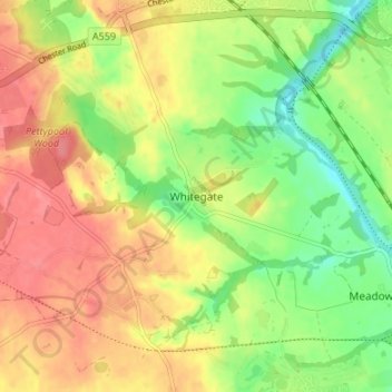
Nom : Carte topographique Whitegate, altitude, relief.
Altitude moyenne : 49 m
Altitude minimum : 13 m
Altitude maximum : 81 m
Autres cartes topographiques
Cliquez sur une carte pour visualiser sa topographie, son altitude et son relief.
Great Boughton
United Kingdom > England > Cheshire West and Chester > Great Boughton
Altitude moyenne : 28 m
Countess of Chester Country Park
United Kingdom > England > Cheshire West and Chester > Chester
Altitude moyenne : 21 m
Burwardsley
United Kingdom > England > Cheshire West and Chester > Burwardsley
Altitude moyenne : 113 m
Frodsham
United Kingdom > England > Cheshire West and Chester
Several faults run roughly northwest–southeast through the area, notably the Overton Fault, which roughly parallels the B5439 and B5152 roads, and the Frodsham Fault, which runs north from the vicinity of Crowmere to the mouth of the River Weaver. Both of these faults and others in the area downthrow to the…
Altitude moyenne : 49 m
River Mersey
United Kingdom > England > Cheshire West and Chester > Bromborough
Altitude moyenne : 8 m
Bolesworth Fish Pond
United Kingdom > England > Cheshire West and Chester > Harthill > Broxton
Altitude moyenne : 75 m
Wirral Country Park
United Kingdom > England > Cheshire West and Chester > Neston > Windle Hill
Altitude moyenne : 49 m
Peckforton Castle
United Kingdom > England > Cheshire West and Chester > Beeston
Peckforton Castle stands in a wooded area near the northern extremity of Peckforton Hills at an elevation of 469.2 feet (143 m). The land falls steeply downwards to the north and the west of the castle, and the Sandstone Trail, a long-distance footpath, runs along the base of these slopes. The ruins of Beeston…
Altitude moyenne : 83 m
Little Stanney
United Kingdom > England > Cheshire West and Chester > Ellesmere Port
Altitude moyenne : 21 m
Dutton Small Lock (Disused)
United Kingdom > England > Cheshire West and Chester > Acton Bridge > Dutton
Altitude moyenne : 28 m
Little Leigh
United Kingdom > England > Cheshire West and Chester > Little Leigh
Altitude moyenne : 38 m
Ness Wood
United Kingdom > England > Cheshire West and Chester > Neston > Ness
Altitude moyenne : 53 m
Christleton
United Kingdom > England > Cheshire West and Chester > Brown Heath
Altitude moyenne : 29 m
Black Diamond Park
United Kingdom > England > Cheshire West and Chester > Chester
Altitude moyenne : 21 m