
Carte topographique Malpas
Cliquez sur la carte pour afficher l’altitude.
À propos de cette carte
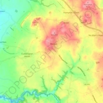
Nom : Carte topographique Malpas, altitude, relief.
Lieu : Malpas, Cheshire West and Chester, England, United Kingdom (52.98945 -2.81694 53.04569 -2.73780)
Altitude moyenne : 86 m
Altitude minimum : 35 m
Altitude maximum : 135 m
Autres cartes topographiques
Cliquez sur une carte pour visualiser sa topographie, son altitude et son relief.
Stamford Bridge
United Kingdom > England > Cheshire West and Chester > Great Barrow
Altitude moyenne : 24 m
Hapsford
United Kingdom > England > Cheshire West and Chester > Dunham on the Hill
Altitude moyenne : 20 m
Dutton Locks
United Kingdom > England > Cheshire West and Chester > Acton Bridge > Dutton
Altitude moyenne : 28 m
Countess of Chester Country Park
United Kingdom > England > Cheshire West and Chester > Chester
Altitude moyenne : 21 m
River Mersey
United Kingdom > England > Cheshire West and Chester > Bromborough
Altitude moyenne : 8 m
Delamere Forest
United Kingdom > England > Cheshire West and Chester
This part of Delamere Forest is undulating in character, with elevations predominantly in the range 60–90 metres. It is composed of numerous hummocks and peatland basins, some of which are glacial in origin while others have been created by sand extraction. The basins form lakes and mosses (bogs) within the…
Altitude moyenne : 90 m
Bolesworth Castle
United Kingdom > England > Cheshire West and Chester > Harthill > Broxton
Altitude moyenne : 80 m
Bolesworth Fish Pond
United Kingdom > England > Cheshire West and Chester > Harthill > Broxton
Altitude moyenne : 75 m
Wirral Country Park
United Kingdom > England > Cheshire West and Chester > Neston > Windle Hill
Altitude moyenne : 49 m
Peckforton Castle
United Kingdom > England > Cheshire West and Chester > Beeston
Peckforton Castle stands in a wooded area near the northern extremity of Peckforton Hills at an elevation of 469.2 feet (143 m). The land falls steeply downwards to the north and the west of the castle, and the Sandstone Trail, a long-distance footpath, runs along the base of these slopes. The ruins of Beeston…
Altitude moyenne : 83 m
Eddisbury Hill
United Kingdom > England > Cheshire West and Chester > Delamere
Altitude moyenne : 103 m
Dutton Small Lock (Disused)
United Kingdom > England > Cheshire West and Chester > Acton Bridge > Dutton
Altitude moyenne : 28 m
Broken Cross
United Kingdom > England > Cheshire West and Chester > Lostock Green
Altitude moyenne : 28 m
Eddisbury Hill Fort
United Kingdom > England > Cheshire West and Chester > Delamere
Altitude moyenne : 103 m
Bostock Green
United Kingdom > England > Cheshire West and Chester > Bostock Green
Altitude moyenne : 36 m
Brown Heath
United Kingdom > England > Cheshire West and Chester > Brown Heath
Altitude moyenne : 30 m
Meadowbank
United Kingdom > England > Cheshire West and Chester > Winsford > Meadowbank
Altitude moyenne : 40 m
Delamere Forest
United Kingdom > England > Cheshire West and Chester
This part of Delamere Forest is undulating in character, with elevations predominantly in the range 60–90 metres. It is composed of numerous hummocks and peatland basins, some of which are glacial in origin while others have been created by sand extraction. The basins form lakes and mosses (bogs) within the…
Altitude moyenne : 90 m
Black Diamond Park
United Kingdom > England > Cheshire West and Chester > Chester
Altitude moyenne : 21 m