
Faire un don
Équipez-vous pour votre prochaine aventure :
En tant que Partenaire Amazon, ce site perçoit une commission sur les achats éligibles sans surcoût pour vous.
Carte topographique Zhangshi
Cliquez sur la carte pour afficher l’altitude.
Faire un don
Équipez-vous pour votre prochaine aventure :
En tant que Partenaire Amazon, ce site perçoit une commission sur les achats éligibles sans surcoût pour vous.
À propos de cette carte
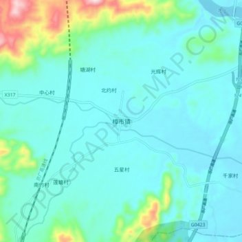
Nom : Carte topographique Zhangshi, altitude, relief.
Altitude moyenne : 103 m
Altitude minimum : 37 m
Altitude maximum : 448 m
Faire un don
Équipez-vous pour votre prochaine aventure :
En tant que Partenaire Amazon, ce site perçoit une commission sur les achats éligibles sans surcoût pour vous.
Autres cartes topographiques
Cliquez sur une carte pour visualiser sa topographie, son altitude et son relief.
Chaozhou
The Chaozhou territory is mountainous. In particular, the nearby Phoenix Mountain's peak is located 1,497 meters (4,911 ft) above sea level. The main nearby rivers are the Huanggang River and the Han River. The Han River flows from west to southeast, and ramps through downtown Chaozhou; the Huanggang river…
Altitude moyenne : 209 m
Huangpu District
China > Guangdong Province > Guangzhou City
The district is pioneering in the low-altitude economy, which includes the development of aerial innovations. Notably, EHang Holdings, based in Huangpu, received the first certification for manned eVTOL (electric vertical take-off and landing) aircraft, positioning the district at the forefront of the urban…
Altitude moyenne : 45 m
Faire un don
Équipez-vous pour votre prochaine aventure :
En tant que Partenaire Amazon, ce site perçoit une commission sur les achats éligibles sans surcoût pour vous.
Guangzhou City
The elevation of the prefecture generally increases from southwest to northeast, with mountains forming the backbone of the city and the ocean comprising the front. Tiantang Peak is the highest point of elevation at 1,210 metres (3,970 feet) above sea level.
Altitude moyenne : 98 m
Faire un don
Équipez-vous pour votre prochaine aventure :
En tant que Partenaire Amazon, ce site perçoit une commission sur les achats éligibles sans surcoût pour vous.
Zhujiangkou Chinese White Dolphin National Nature Reserve
Altitude moyenne : 6 m
Faire un don
Équipez-vous pour votre prochaine aventure :
En tant que Partenaire Amazon, ce site perçoit une commission sur les achats éligibles sans surcoût pour vous.
Faire un don
Équipez-vous pour votre prochaine aventure :
En tant que Partenaire Amazon, ce site perçoit une commission sur les achats éligibles sans surcoût pour vous.
Chaozhou
The Chaozhou territory is mountainous. In particular, the nearby Phoenix Mountain's peak is located 1,497 meters (4,911 ft) above sea level. The main nearby rivers are the Huanggang River and the Han River. The Han River flows from west to southeast, and ramps through downtown Chaozhou; the Huanggang river…
Altitude moyenne : 209 m
Faire un don
Équipez-vous pour votre prochaine aventure :
En tant que Partenaire Amazon, ce site perçoit une commission sur les achats éligibles sans surcoût pour vous.
Faire un don
Équipez-vous pour votre prochaine aventure :
En tant que Partenaire Amazon, ce site perçoit une commission sur les achats éligibles sans surcoût pour vous.
Nanshan District
At 587 meters (1,926 ft) tall, Yangtaishan has the highest elevation in the district, with Tanglangshan being the second at 430 meters (1,411 ft), and Nanshan, third, at 336 meters (1,102 ft). The district has a total coastline of 55.18 kilometers (34.29 mi).
Altitude moyenne : 35 m
Shenzhen Bay Port Hong Kong Port Area
China > Guangdong Province > Nanshan District
Altitude moyenne : 1 m
Faire un don
Équipez-vous pour votre prochaine aventure :
En tant que Partenaire Amazon, ce site perçoit une commission sur les achats éligibles sans surcoût pour vous.
Faire un don
Équipez-vous pour votre prochaine aventure :
En tant que Partenaire Amazon, ce site perçoit une commission sur les achats éligibles sans surcoût pour vous.
Faire un don
Équipez-vous pour votre prochaine aventure :
En tant que Partenaire Amazon, ce site perçoit une commission sur les achats éligibles sans surcoût pour vous.
Faire un don
Équipez-vous pour votre prochaine aventure :
En tant que Partenaire Amazon, ce site perçoit une commission sur les achats éligibles sans surcoût pour vous.
Guangdong-Macao In-Depth Cooperation Zone in Hengqin
Altitude moyenne : 20 m
Faire un don
Équipez-vous pour votre prochaine aventure :
En tant que Partenaire Amazon, ce site perçoit une commission sur les achats éligibles sans surcoût pour vous.
Faire un don
Équipez-vous pour votre prochaine aventure :
En tant que Partenaire Amazon, ce site perçoit une commission sur les achats éligibles sans surcoût pour vous.
Faire un don
Équipez-vous pour votre prochaine aventure :
En tant que Partenaire Amazon, ce site perçoit une commission sur les achats éligibles sans surcoût pour vous.
Meizhou
Meizhou has a humid subtropical climate (Köppen Cfa), with short, mild, overcast winters and long, very hot, humid summers. The monthly daily average temperature in January is 12.6 °C (54.7 °F), and in July is 28.9 °C (84.0 °F). From April to June, rainfall is the heaviest and most frequent. Though…
Altitude moyenne : 297 m
Hengli
China > Guangdong Province > Dongguan
Hengli Town is located on the banks of Huanbao and Yinhe Rivers. The Congguanshen Expressway crosses the eastern part of the town. It has an average elevation of 8 meters above the sea level.
Altitude moyenne : 8 m
Faire un don
Équipez-vous pour votre prochaine aventure :
En tant que Partenaire Amazon, ce site perçoit une commission sur les achats éligibles sans surcoût pour vous.
Faire un don
Équipez-vous pour votre prochaine aventure :
En tant que Partenaire Amazon, ce site perçoit une commission sur les achats éligibles sans surcoût pour vous.
Faire un don
Équipez-vous pour votre prochaine aventure :
En tant que Partenaire Amazon, ce site perçoit une commission sur les achats éligibles sans surcoût pour vous.
Guangzhou City
The elevation of the prefecture generally increases from southwest to northeast, with mountains forming the backbone of the city and the ocean comprising the front. Tiantang Peak (simplified Chinese: 天堂顶; traditional Chinese: 天堂頂, "Heavenly Peak") is the highest point of elevation at 1,210 m (3,970…
Altitude moyenne : 98 m
Faire un don
Équipez-vous pour votre prochaine aventure :
En tant que Partenaire Amazon, ce site perçoit une commission sur les achats éligibles sans surcoût pour vous.
Faire un don
Équipez-vous pour votre prochaine aventure :
En tant que Partenaire Amazon, ce site perçoit une commission sur les achats éligibles sans surcoût pour vous.
Faire un don
Équipez-vous pour votre prochaine aventure :
En tant que Partenaire Amazon, ce site perçoit une commission sur les achats éligibles sans surcoût pour vous.
Faire un don
Équipez-vous pour votre prochaine aventure :
En tant que Partenaire Amazon, ce site perçoit une commission sur les achats éligibles sans surcoût pour vous.
Faire un don
Équipez-vous pour votre prochaine aventure :
En tant que Partenaire Amazon, ce site perçoit une commission sur les achats éligibles sans surcoût pour vous.
Futian Sub-district
China > Guangdong Province > Futian District > Futian Sub-district
Altitude moyenne : 8 m
Faire un don
Équipez-vous pour votre prochaine aventure :
En tant que Partenaire Amazon, ce site perçoit une commission sur les achats éligibles sans surcoût pour vous.
Xili Sub-district
China > Guangdong Province > Nanshan District > Xili Sub-district
Altitude moyenne : 67 m
Lianhua Sub-district
China > Guangdong Province > Futian District > Lianhua Sub-district
Altitude moyenne : 21 m
Tianchi (Heaven Lake)
China > Guangdong Province > Chao'an District > Fenghuang
Altitude moyenne : 1 053 m
Faire un don
Équipez-vous pour votre prochaine aventure :
En tant que Partenaire Amazon, ce site perçoit une commission sur les achats éligibles sans surcoût pour vous.
Qingyuan City
Qingyuan's administrative area ranges in latitude from 23° 26' 56" to 25° 11' 40" N, and in longitude from 111° 55' 17" to 113° 55' 34" E; its urban area is located just north of the Tropic of Cancer, about 60 km (37 mi) from the urban area of Guangzhou and 200 km (120 mi) from both Hong Kong and Macau.…
Altitude moyenne : 349 m
Taoyuan Sub-district
China > Guangdong Province > Nanshan District > Taoyuan Sub-district
Altitude moyenne : 56 m
Faire un don
Équipez-vous pour votre prochaine aventure :
En tant que Partenaire Amazon, ce site perçoit une commission sur les achats éligibles sans surcoût pour vous.
Faire un don
Équipez-vous pour votre prochaine aventure :
En tant que Partenaire Amazon, ce site perçoit une commission sur les achats éligibles sans surcoût pour vous.