
Faire un don
Équipez-vous pour votre prochaine aventure :
En tant que Partenaire Amazon, ce site perçoit une commission sur les achats éligibles sans surcoût pour vous.
Carte topographique Delta County
Cliquez sur la carte pour afficher l’altitude.
Faire un don
Équipez-vous pour votre prochaine aventure :
En tant que Partenaire Amazon, ce site perçoit une commission sur les achats éligibles sans surcoût pour vous.
À propos de cette carte
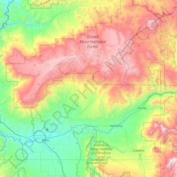
Nom : Carte topographique Delta County, altitude, relief.
Lieu : Delta County, Colorado, United States (38.66797 -108.37897 39.21813 -107.49928)
Altitude moyenne : 2 271 m
Altitude minimum : 1 459 m
Altitude maximum : 3 592 m
Faire un don
Équipez-vous pour votre prochaine aventure :
En tant que Partenaire Amazon, ce site perçoit une commission sur les achats éligibles sans surcoût pour vous.
Autres cartes topographiques
Cliquez sur une carte pour visualiser sa topographie, son altitude et son relief.
Monument
United States > Colorado > El Paso County
Monument experiences a hemiboreal continental climate (Köppen Dfb) with warm, relatively rainy summers and cold, snowy winters. The semi-arid climate keeps the dew point very low in Monument year-round which causes the air to feel quite dry. Monument is part of the Front Range urban corridor and lies on the…
Altitude moyenne : 2 160 m
Mountain Village
United States > Colorado > San Miguel County
Mountain Village is a home rule municipality in San Miguel County, southwestern Colorado. It is located just southwest of Telluride, Colorado in the San Juan Mountains. The elevation of the town rises above Telluride to 9,600 feet. The population was 1,264 at the 2020 census.
Altitude moyenne : 2 917 m
Faire un don
Équipez-vous pour votre prochaine aventure :
En tant que Partenaire Amazon, ce site perçoit une commission sur les achats éligibles sans surcoût pour vous.
Faire un don
Équipez-vous pour votre prochaine aventure :
En tant que Partenaire Amazon, ce site perçoit une commission sur les achats éligibles sans surcoût pour vous.
Telluride
United States > Colorado > San Miguel County > Telluride
Telluride has an elevation of 8,750 feet (2,670 m) in an isolated spot in Southwest Colorado. From the west, Colorado Route 145 is the most common way into Telluride; two other passes enter the town, Imogene Pass and Black Bear Pass.
Altitude moyenne : 3 246 m
Vail
United States > Colorado > Eagle County > Vail
Vail's average elevation is 8,150 feet (2484 m) above sea level. The town has a total area of 4.5 square miles (12 km2), with no lakes (there is, however, at least one pond). Gore Creek flows from east to west through the center of town.
Altitude moyenne : 2 953 m
Colorado Springs
United States > Colorado > El Paso County > Colorado Springs
Snowfall is usually moderate and remains on the ground briefly because of direct sun, with the city receiving 38 inches (97 cm) per season, although the mountains to the west often receive in excess of triple that amount; March is the snowiest month in the region, both by total accumulation and number of days…
Altitude moyenne : 2 229 m
Faire un don
Équipez-vous pour votre prochaine aventure :
En tant que Partenaire Amazon, ce site perçoit une commission sur les achats éligibles sans surcoût pour vous.