
Carte topographique Kanungu Town Council
Carte interactive
Cliquez sur la carte pour afficher l’altitude.
À propos de cette carte
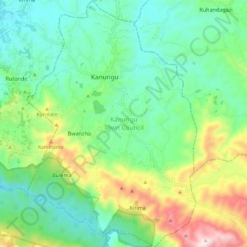
Nom : Carte topographique Kanungu Town Council, altitude, relief.
Lieu : Kanungu Town Council, Kanungu, Western Region, Ouganda (-0.95609 29.74840 -0.87038 29.80748)
Altitude moyenne : 1 639 m
Altitude minimum : 1 402 m
Altitude maximum : 2 203 m
Autres cartes topographiques
Cliquez sur une carte pour visualiser sa topographie, son altitude et son relief.
Nyaka Sub-County
Nyaka Sub-County, Kanungu, Western Region, Ouganda
Altitude moyenne : 1 017 m
Mpungu Sub-County
Mpungu Sub-County, Kanungu, Western Region, Ouganda
Altitude moyenne : 1 716 m
Kayonza Sub-County
Kayonza Sub-County, Kanungu, Western Region, Ouganda
Altitude moyenne : 1 386 m