
Carte topographique Ocean City
Carte interactive
Cliquez sur la carte pour afficher l’altitude.
À propos de cette carte
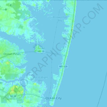
Nom : Carte topographique Ocean City, altitude, relief.
Lieu : Ocean City, Worcester County, Maryland, United States (38.32409 -75.09345 38.45126 -75.04913)
Altitude moyenne : 1 m
Altitude minimum : -5 m
Altitude maximum : 19 m
Autres cartes topographiques
Cliquez sur une carte pour visualiser sa topographie, son altitude et son relief.
West Ocean City
United States > Maryland > Worcester County > West Ocean City
West Ocean City, Worcester County, Maryland, United States
Altitude moyenne : 2 m
Stockton
United States > Maryland > Worcester County > Stockton
Stockton, Worcester County, Maryland, United States
Altitude moyenne : 8 m
Snow Hill
United States > Maryland > Worcester County
Snow Hill, Worcester County, Maryland, United States
Altitude moyenne : 7 m
Ocean Pines
United States > Maryland > Worcester County
Ocean Pines, Worcester County, Maryland, United States
Altitude moyenne : 3 m
Assateague Island National Seashore
United States > Maryland > Worcester County > West Ocean City
Assateague Island National Seashore, West Ocean City, Worcester County, Maryland, United States
Altitude moyenne : 2 m
Newark
United States > Maryland > Worcester County > Newark
Newark, Worcester County, Maryland, United States
Altitude moyenne : 10 m
Worcester County
United States > Maryland > Worcester County
Worcester County, Maryland, United States
Altitude moyenne : 6 m