
Carte topographique Worcester County
Carte interactive
Cliquez sur la carte pour afficher l’altitude.
À propos de cette carte
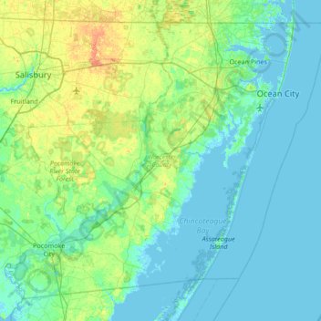
Nom : Carte topographique Worcester County, altitude, relief.
Lieu : Worcester County, Maryland, United States (37.99428 -75.66177 38.45204 -74.98520)
Altitude moyenne : 6 m
Altitude minimum : -3 m
Altitude maximum : 28 m
The terrain is mostly level and coastal. The lowest elevation is sea level along the Atlantic Ocean and the highest elevation is 49 ft (15 m) in the northwestern part of the county along State Route 12 just south of the Wicomico County line.
Autres cartes topographiques
Cliquez sur une carte pour visualiser sa topographie, son altitude et son relief.
West Ocean City
United States > Maryland > Worcester County > West Ocean City
West Ocean City, Worcester County, Maryland, United States
Altitude moyenne : 2 m
Ocean City
United States > Maryland > Worcester County
Ocean City, Worcester County, Maryland, United States
Altitude moyenne : 1 m
Stockton
United States > Maryland > Worcester County > Stockton
Stockton, Worcester County, Maryland, United States
Altitude moyenne : 8 m
Snow Hill
United States > Maryland > Worcester County
Snow Hill, Worcester County, Maryland, United States
Altitude moyenne : 7 m
Ocean Pines
United States > Maryland > Worcester County
Ocean Pines, Worcester County, Maryland, United States
Altitude moyenne : 3 m
Assateague Island National Seashore
United States > Maryland > Worcester County > West Ocean City
Assateague Island National Seashore, West Ocean City, Worcester County, Maryland, United States
Altitude moyenne : 2 m
Newark
United States > Maryland > Worcester County > Newark
Newark, Worcester County, Maryland, United States
Altitude moyenne : 10 m